Energy / Gulf Coast
Federal Report: 343 Trillion Cubic Feet of Undiscovered Gas Sits Beneath the Gulf Coast—And a Separate Offshore Zone Covers Northwest Florida Waters
A sweeping new USGS assessment of the Bossier Formation confirms massive onshore shale gas reserves across the Gulf Coast region—and identifies a separate conventional oil and gas zone in offshore Gulf waters from Mississippi to Escambia, Santa Rosa, and Okaloosa counties.
The U.S. Geological Survey released its most comprehensive assessment yet of undiscovered petroleum in the Jurassic Bossier Formation along the Gulf Coast this week, estimating 343.5 trillion cubic feet of technically recoverable natural gas across the region—enough to supply the entire United States for more than a decade at current consumption rates—along with 3 million barrels of oil and 374 million barrels of natural gas liquids. Read USGS Assessment Report
- The bulk of those resources lie in deep onshore shale plays across Texas, Arkansas, and Louisiana. But a separate zone in the assessment carries direct implications for Northwest Florida: the Bossier Conventional Oil and Gas Assessment Unit covers offshore Gulf waters adjacent to Mississippi and the Florida Panhandle, including waters off Escambia, Santa Rosa, and Okaloosa counties.
- That conventional zone carries estimated mean resources of 648 billion cubic feet of gas and 3 million barrels of oil—and federal geologists assign it a probability of 1.0, meaning they are certain undiscovered resources exist there.
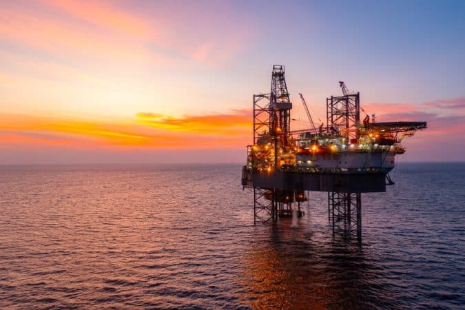
Offshore production rigs within sight of Pensacola-area beaches may not be as far-fetched as it sounds.
What the Assessment Found
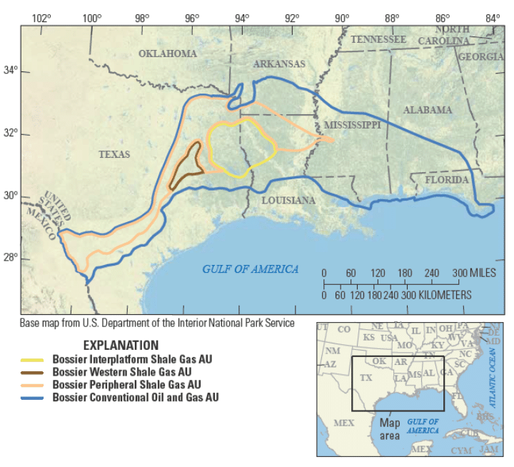 The USGS assessed four distinct zones—called assessment units—within the Bossier Formation, which lies in the subsurface across Texas, Arkansas, Louisiana, Mississippi, Alabama, and Florida:
- Bossier Interplatform Shale Gas AU — The primary shale gas production area, centered on the Sabine Uplift in East Texas and northwestern Louisiana, with estimated mean resources of 84.3 trillion cubic feet of gas.
- Bossier Western Shale Gas AU — The highest-potential new play, known in industry as the “Western Haynesville,” characterized by extreme overpressure and deep high-temperature shales. Mean estimated resources: 203.2 trillion cubic feet of gas—the single largest zone in the assessment.
- Bossier Peripheral Shale Gas AU — The surrounding shale area with lower fracture density, estimated mean resources of 55.4 trillion cubic feet of gas.
- Bossier Conventional Oil and Gas AU — Sandstone and carbonate reservoirs in traditional structural traps, covering offshore Gulf waters including the Panhandle coast. Estimated mean: 648 billion cubic feet of gas and 3 million barrels of oil.
“The U.S. economy and our way of life depend on energy, and USGS oil and gas assessments point to resources that industry hasn’t discovered yet. In this case, we have assessed there are significant undiscovered resources in the Bossier Formation.”
— USGS Director Ned Mamula
The “Western Haynesville” Changes the Picture
The reassessment was triggered by a development that rattled the energy industry: exploration drilling on the western flank of the East Texas Basin revealed deep, highly overpressured shales with production rates far exceeding typical Bossier wells. The play is widely called the “Western Haynesville” by industry. A Wall Street Journal report last October noted that Dallas Cowboys owner Jerry Jones, through his Comstock Resources stake, claimed to have identified what he described as a $100 billion gas opportunity in the zone.
- USGS geologists confirmed the gas is actually being produced from the Bossier Formation—not the Haynesville—based on analysis of well logs, seismic data, and well landing zones. The Western Shale Gas AU carries the highest estimated ultimate recoveries of any zone in the assessment, with average EUR inputs ranging from 15 to 35 million barrels of oil equivalent per well.
Since production began, the Bossier Formation has already produced 3.8 trillion cubic feet of gas—nearly six weeks of U.S. consumption at the record 2025 level. The formation is tapped from depths up to 18,000 feet, making it one of the deepest active production plays on the Gulf Coast.
What It Means for the Pensacola Area
The conventional zone covering Northwest Florida offshore waters is geologically distinct from the massive onshore shale plays. Here, the resource model involves gas and oil from Jurassic source rocks migrating upward into sandstone and carbonate reservoirs, trapped by faults, salt tectonics, and stratigraphic changes. It is a smaller but separately confirmed play.
- USGS notes the conventional zone faces a key limiting factor: the general lack of sealing lithologies—the rock layers that hold hydrocarbons in place—may constrain total recoverable volumes. Still, the agency assessed a probability of 1.0 for the AU, meaning geologists consider it a certainty that resources exist; the question is scale and whether industry pursues development.
• Mean estimated gas: 648 billion cubic feet (F95–F5 range: 244–1,284 BCF)
• Mean estimated oil: 3 million barrels (F95–F5 range: 1–8 MMBO)
• AU probability: 1.0 (resources confirmed to exist)
• Geographic scope: Offshore Gulf waters, Mississippi through Escambia, Santa Rosa, and Okaloosa counties, Florida
Whether offshore development materializes depends on federal permitting, energy prices, and industry investment decisions. But the USGS assessment puts the Panhandle coast formally on the map as an undiscovered resource province—a designation that carries weight with exploration planners and federal land managers alike.
The full fact sheet on the Bossier Formation assessment is available at the USGS Energy Resources Program website.