A tropical weather system is developing near the Yucatan Peninsula and has a 70% chance of strengthening. Escambia County Public Safety Director Eric Gilmore will be my guest on “Real News with Rick Outzen” at 7 a.m.
Tropical Weather Outlook
NWS National Hurricane Center Miami FL
200 AM EDT Mon Sep 23 2024
For the North Atlantic…Caribbean Sea and the Gulf of Mexico:
1. Northwestern Caribbean Sea and Gulf of Mexico (AL97):
Showers and thunderstorms are beginning to show signs of
organization with a broad area of low pressure located over the
northwestern Caribbean Sea. Environmental conditions appear
favorable for further development of this system, and a tropical
depression or storm is likely to form over the next couple of days
as the system moves northward across the northwestern Caribbean Sea
and into the southeastern Gulf of Mexico where additional
development is possible.
Regardless of development, this system is expected to produce heavy
rains over portions of Central America during the next several days.
Interests in the northwestern Caribbean, the Yucatan Peninsula of
Mexico, and western Cuba should closely monitor the progress of this
system. Later this week, the system is forecast to move generally
northward across the eastern Gulf of Mexico, and interests along the
northern and northeastern Gulf Coast should also closely monitor
the progress of this system.
* Formation chance through 48 hours…high…70 percent.
* Formation chance through 7 days…high…90 percent.
ACCUWEATHER
Hurricane forecast to make landfall along US Gulf Coast this week
People along the Florida Panhandle, Big Bend region and much of the eastern Gulf coast need to complete preparations for hurricane impacts by Wednesday night before hazardous conditions arrive on Thursday.
By Bill Deger, AccuWeather senior meteorologist
Published Sep 21, 2024 10:21 AM CDT | Updated Sep 23, 2024 5:02 AM CDT
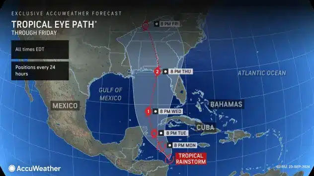
n evolving storm in the western Caribbean is expected to intensify into a hurricane before moving north and making landfall along the United States Gulf Coast on Thursday, AccuWeather expert meteorologists are forecasting.
Residents along much of the Gulf Coast need to complete preparations for hurricane impacts by Wednesday night before hazardous conditions arrive on Thursday, AccuWeather hurricane experts advised.
“Everyone along the Florida Panhandle and Big Bend region needs to be prepared for hurricane impacts,” said AccuWeather Lead Hurricane Expert Alex DaSilva, adding that the setup has the potential to become the strongest hurricane landfall in the U.S. so far this season.
“The region we are closely watching is more commonly a threat to tropical development in the late-spring or mid- to late-autumn seasons,” said DaSilva. “There’s even evidence of the Central America gyre now, which is also more common in the spring and later in the autumn.”
Read more.
TWO LANDFALL SCENARIOS
WEATHER CHANNEL
Here is when a storm could form and where it could track:
-? Monday-Tuesday: The latest computer forecast models suggest a tropical depression or storm could form as soon as late Monday or Tuesday. By late Tuesday, Helene could near Cancún, Cozumel and western Cuba as either a tropical storm or even a Category 1 hurricane. Locally heavy rain and strong wind gusts are possible in those areas.
– Wednesday: Helene could have some lingering impacts in Cancún, Cozumel and western Cuba, especially early. We then expect Helene to enter the southern Gulf of Mexico, most likely as a hurricane. Some high surf and outer rainbands could reach parts of Florida’s Gulf Coast from the Keys to the Panhandle.
– Thursday: While still some uncertainty in the forecast, we expect Helene to make landfall as a hurricane, possibly a strong one, sometime Thursday. While computer forecast models suggest the most likely location for a landfall is somewhere from Florida’s Big Bend to the Panhandle, remember that hurricane impacts (surge, winds, rain) often happen far from the center.? There are still a few computer ensemble model forecasts with tracks as far east as Florida’s West Coast and as far west as southeast Louisiana. So, everyone along the northern Gulf Coast from Louisiana to Florida should continue to monitor this forecast for any possible changes ahead.
– Friday: This system is most likely to continue inland with weakening winds, but locally flooding rain over parts of the Southeast.
Read more.
