At 10:10 p.m. CDT, Hurricane Helene made landfall near Perry, Fla., as a Category 4 storm with 140-mph winds. About 80% of the residents in Dixie, Gilchrist, Lafayette, Levy, Suzanne and Taylor counties lost electricity, according to PowerOutage.us.
Local crews – Escambia County Emergency Management and Escambia County Sheriff’s Office – will be heading to Liberty County today.
From NOAA Hurricane Center – 4 a.m.
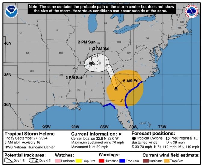
Tropical Storm Helene Advisory Number 16
NWS National Hurricane Center Miami FL AL092024
500 AM EDT Fri Sep 27 2024
…HELENE WEAKENS TO A TROPICAL STORM AS IT MOVES FARTHER INLAND
OVER GEORGIA…
…LIFE-THREATENING STORM SURGE, WINDS, AND HEAVY RAINS
CONTINUE…
SUMMARY OF 500 AM EDT…0900 UTC…INFORMATION
———————————————-
LOCATION…32.8N 83.0W
ABOUT 40 MI…65 KM E OF MACON GEORGIA
ABOUT 100 MI…165 KM SE OF ATLANTA GEORGIA
MAXIMUM SUSTAINED WINDS…70 MPH…110 KM/H
PRESENT MOVEMENT…N OR 360 DEGREES AT 30 MPH…48 KM/H
MINIMUM CENTRAL PRESSURE…968 MB…28.59 INCHES
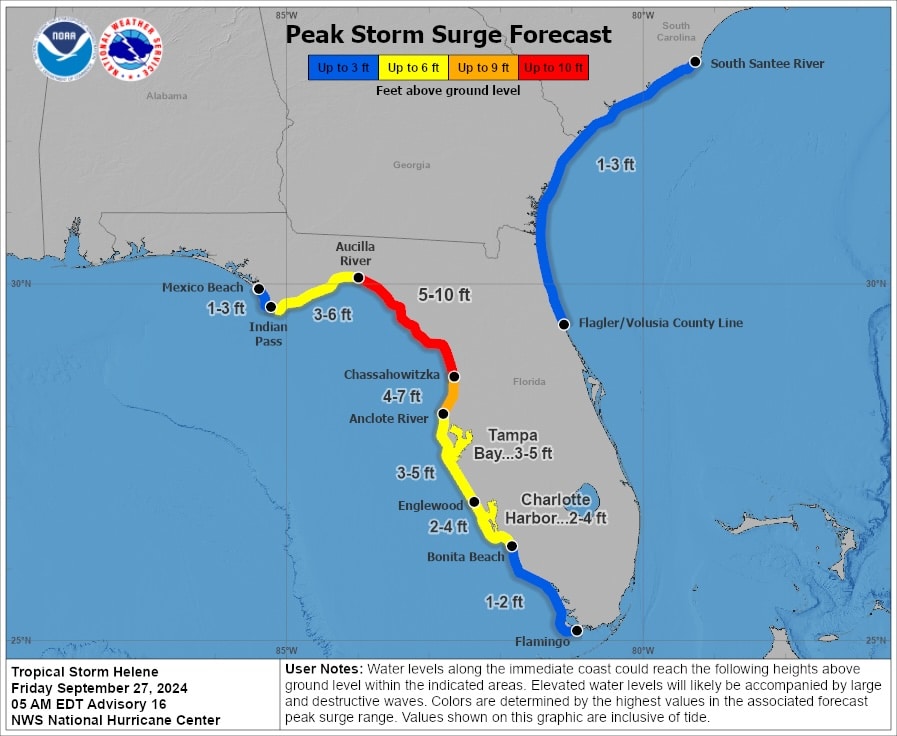
WATCHES AND WARNINGS
——————–
CHANGES WITH THIS ADVISORY:
All Hurricane and Tropical Storm warnings have been discontinued
along the Florida east coast south of the Flagler/Volusia county
line, and along the Florida west coast south of the mouth of the
Suwannee River.
The Hurricane Warning for the Florida coast from the mouth of the
Suwannee Rover to Mexico Beach has been changed to a Tropical Storm
Warning.
The Tropical Storm Warning has been discontinued for the Florida
Gulf coast west of Indian Pass.
The Storm Surge Warning for the Florida coast has been discontinued
west of Indian Pass and south of Bonita Beach.
The Hurricane Watch for the Florida West coast has been
discontinued.
DISCUSSION AND OUTLOOK
———————-
At 500 AM EDT (0900 UTC), the center of Tropical Storm Helene was
located near latitude 32.8 North, longitude 83.0 West. Helene is
moving toward the north near 30 mph (48 km/h). A turn toward the
north is expected this morning, taking the center over central and
northeastern Georgia. After that, Helene is expected to turn
northwestward and slow down over the Tennessee Valley later today
and Saturday.
Maximum sustained winds have decreased to near 70 mph (110 km/h)
with higher gusts. Continued weakening is expected, and Helene is
expected to become a post-tropical low this afternoon or tonight.
However, the fast forward speed will allow strong, damaging winds,
especially in gusts, to penetrate well inland across the
southeastern United States, including over the higher terrain of
the southern Appalachians.
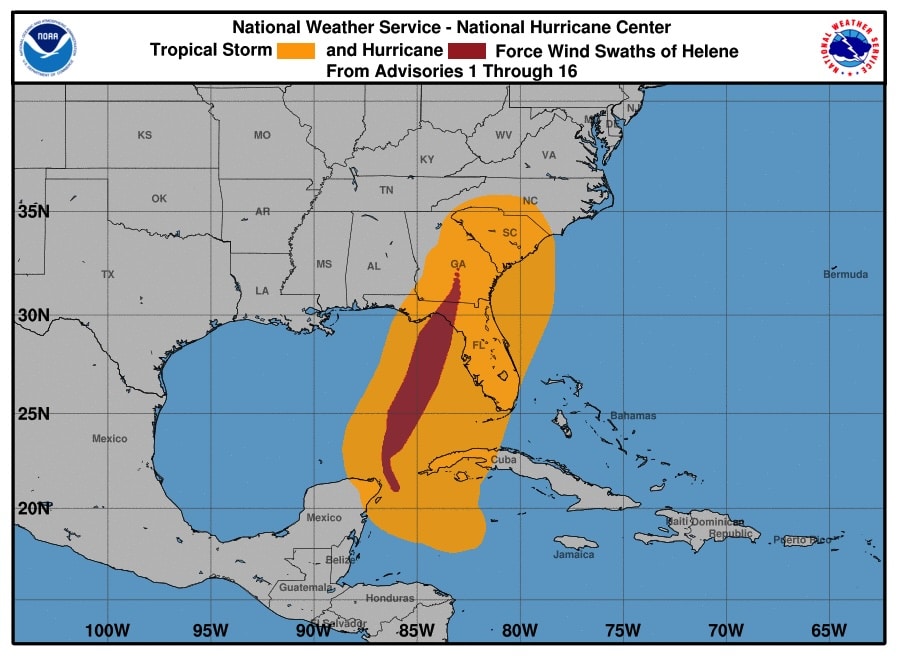
Tropical-storm-force winds extend outward up to 275 miles (445 km)
mainly to the east of the center. The Marine Corp Air Station at
Beaufort, South Carolina, recently reported a wind gust of 75 mph
(120 km/h).
Read more.