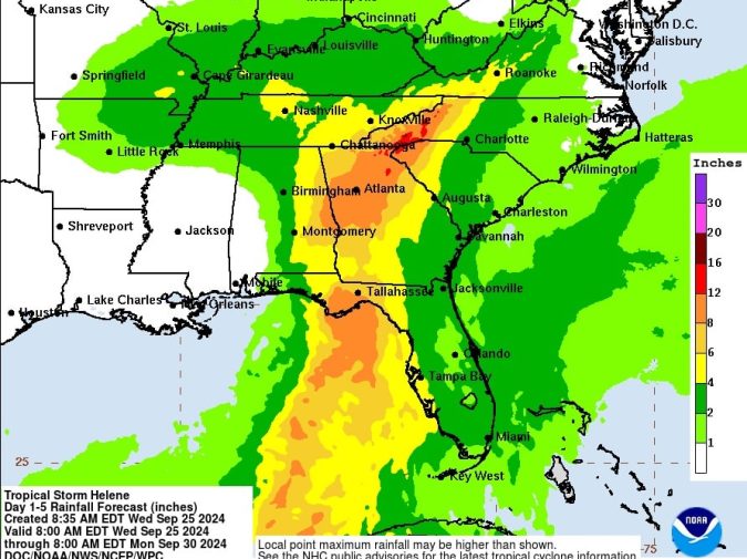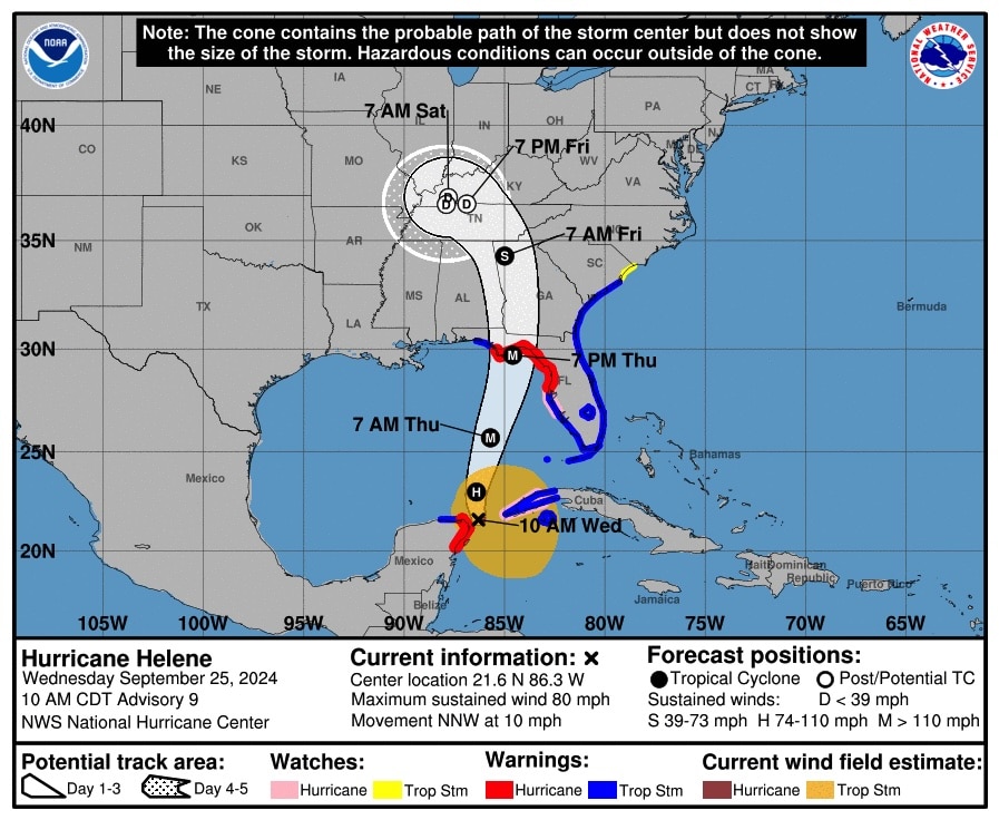
Helene is in the Gulf of Mexico and has been upgraded to a hurricane. It’s expected to make landfall in the big Bend area of Florida on Thursday evening.
The Tropical Storm Warning has been extended to the Okaloosa/Walton County Line.

From NOAA Hurricane Center:
BULLETIN
Hurricane Helene Advisory Number 9
NWS National Hurricane Center Miami FL AL092024
1000 AM CDT Wed Sep 25 2024
…HELENE BECOMES A HURRICANE…
…EXPECTED TO BRING LIFE-THREATENING STORM SURGE, DAMAGING WINDS,
AND FLOODING RAINS TO A LARGE PORTION OF FLORIDA AND THE
SOUTHEASTERN UNITED STATES…
SUMMARY OF WATCHES AND WARNINGS IN EFFECT:
A Storm Surge Warning is in effect for…
* Indian Pass southward to Flamingo
* Tampa Bay
* Charlotte Harbor
A Hurricane Warning is in effect for…
* Anclote River to Mexico Beach
* Cabo Catoche to Tulum, Mexico including Cozumel
A Storm Surge Watch is in effect for…
* West of Indian Pass to Mexico Beach
A Hurricane Watch is in effect for…
* Cuban province of Pinar del Rio
* Englewood to Anclote River, including Tampa Bay
A Tropical Storm Warning is in effect for…
* Florida Keys, including the Dry Tortugas
* Flamingo to Anclote River, including Tampa Bay
* West of Mexico Beach to the Okaloosa/Walton County Line
* Flamingo northward to South Santee River
* Lake Okeechobee
* Rio Lagartos to Cabo Catoche, Mexico
* Cuban provinces of Artemisa, Pinar del Rio, and the Isle of Youth
A Tropical Storm Watch is in effect for…
* North of South Santee River to Little River Inlet
A Tropical Storm Warning means that tropical storm conditions are
expected somewhere within the warning area within the next 36 hours.
At 1000 AM CDT (1500 UTC), the center of Hurricane Helene was
located near latitude 21.6 North, longitude 86.3 West. Helene is
moving toward the north-northwest near 10 mph (17 km/h). A turn
toward the north and north-northeast with an increase in forward
speed is expected later today through Thursday, bringing the center
of Helene across the eastern Gulf of Mexico and to the Florida Big
Bend coast by Thursday evening. After landfall, Helene is expected
to slow down and turn toward the northwest over the southeastern
United States Friday and Saturday.
Data from NOAA and Air Force Reserve Hurricane Hunter aircraft
indicate that maximum sustained winds have increased to near 80 mph
(130 km/h) with higher gusts. Additional strengthening is
forecast, and Helene is expected to be a major hurricane when it
reaches the Florida Big Bend coast Thursday evening. Weakening is
expected after landfall, but Helene’s fast forward speed will allow
strong, damaging winds, especially in gusts, to penetrate well
inland across the southeastern United States, including over the
higher terrain of the southern Appalachians.


