We will provide updates throughout the day as Hurricane Debbie makes landfall in the Big Bend area – most likely near where Hurricane Idalia in August 2023.
Gov. Ron DeSantis has scheduled a press conference in Tallahassee at 6:30 a.m. CDT, and we will have Escambia County Public Safety Director Eric Gilmore on “Real News with Rick Outzen” at 7 a.m. Listen here.
Update 1 p.m.:
Governor DeSantis Issues Updates on State Response; Hurricane Debby Makes Landfall as a Category 1 in the Big Bend
TALLAHASSEE, Fla.—Today, Governor DeSantis provided updates on Hurricane Debby in his third press conference at the State Emergency Operations Center with Florida Division of Emergency Management (FDEM) Executive Director Kevin Guthrie as Hurricane Debby began to make landfall in the Big Bend region.
Hurricane Debby made landfall at 7 am EDT near Steinhatchee, Florida. In anticipation of this, Governor DeSantis issued Executive Order 24-157 on August 2, amending EO 24-156, and declaring a state of emergency for a total of 61 counties.
As of 11 AM EDT, Hurricane Debby was downgraded to a Tropical Storm, and is located about 35 miles west of Lake City, Florida. Debby is then expected to move slowly across northern Florida and southern Georgia Monday and Tuesday.
Maximum sustained winds are near 75 mph and additional weakening is expected as Debby moves over land today and tonight.
As of this morning, approximately 143,000 Floridians are without power. The State of Florida has already restored 322,000 accounts.
As of this morning, Florida Department of Transportation (FDOT) emergency response personnel have completed preliminary assessments of over 4,500 lane miles of state roads.
The State Assistance Information Line (SAIL) is operational. Residents needing resources before and after Hurricane Debby can call 1-800-342-3557. There are English and Spanish speakers available to answer questions.
Hurricane Warnings have been issued for: Coastal Franklin, Wakulla, Jefferson, Madison, Taylor, Hamilton, Suwannee, Lafayette, Dixie, Gilchrist, and Coastal Levy.
Tropical Storm Warnings have been issued for: Gulf, Liberty, Gadsden, Leon, Columbia, Baker, Nassau, Duval, Union, Bradford, St. Johns, Alachua, Putnam, Inland Levy, Marion, Lake, Citrus, Sumter, Lake, Hernando, Pasco, Pinellas, Hillsborough, Manatee, Sarasota and Coastal Charlotte.
Storm Surge Warnings are in effect for: Coastal Franklin, Coastal Wakulla, Coastal Jefferson, Coastal Taylor, Coastal Dixie, Coastal Levy, Coastal Citrus, Coastal Hernando, Coastal Pasco, Coastal Hillsborough (including Tampa Bay), Coastal Manatee, and Pinellas.
FDEM is hosting daily calls with all 67 counties to identify needs and to ensure the state is prepared to respond quickly and efficiently. Additionally, FDEM is coordinating with state agencies, non-governmental organizations, and private sector partners for resource requests.
—–
Update 7:20 am:
—
Debby Makes Landfall in Big Bend
By Jim Turner, The News Service of Florida
TALLAHASSEE — Hurricane Debby made landfall about 7 a.m. Monday near Steinhatchee with maximum sustained winds of 80 mph, bringing the rural Big Bend region its second hurricane in less than a year, according to the National Hurricane Center.
Debby is expected to slow and turn northeast, meandering across North Florida and Southeast Georgia later Monday, with the hurricane center saying it could produce “catastrophic flooding in some locations.”
The storm is expected to move off the southeast U.S. coast late Tuesday, and it could potentially come back inland over South Carolina on Thursday.
Steinhatchee is in Taylor County, roughly 90 miles south of Tallahassee. On Aug. 30, 2023, Hurricane Idalia made landfall in Taylor County’s Keaton Beach with maximum sustained winds of 125 mph and storm surge of 7 to 12 feet along the coast. It then caused widespread damage as it moved across North Florida.
Debby, potentially a historic rainmaker, started pounding the Gulf Coast on Sunday, and more than 150,000 utility customers were without power Monday morning, including more than 25,000 Duke Energy Florida customers in the Tampa Bay region.
The state Division of Emergency Management said tornado watches and warnings were in effect across the state.
——
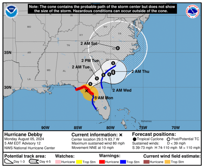
At 4 a.m. (5 a.m. EDT), we received this advisory from the NOAA Hurricane Center:
BULLETIN
Hurricane Debby Advisory Number 12
NWS National Hurricane Center Miami FL AL042024
500 AM EDT Mon Aug 05 2024
…DEBBY VERY NEAR LANDFALL IN THE FLORIDA BIG BEND…
…EXPECTED TO BRING LIFE-THREATENING STORM SURGE IN PORTIONS OF
FLORIDA AND MAJOR FLOODING IN THE SOUTHEASTERN UNITED STATES…
SUMMARY OF 500 AM EDT…0900 UTC…INFORMATION
———————————————-
LOCATION…29.5N 83.7W
ABOUT 45 MI…75 KM NW OF CEDAR KEY FLORIDA
ABOUT 70 MI…115 KM SSE OF TALLAHASSEE FLORIDA
MAXIMUM SUSTAINED WINDS…80 MPH…130 KM/H
PRESENT MOVEMENT…NNE OR 15 DEGREES AT 10 MPH…17 KM/H
MINIMUM CENTRAL PRESSURE…979 MB…28.91 INCHES
WATCHES AND WARNINGS
——————–
SUMMARY OF WATCHES AND WARNINGS IN EFFECT:
A Storm Surge Warning is in effect for…
* Florida coast from the middle of Longboat Key northward to Indian
Pass including Tampa Bay
* Georgia and South Carolina coast from the Mouth of the St. Mary’s
River to South Santee River South Carolina
A Storm Surge Watch is in effect for…
* Florida coast from Englewood northward to the middle of
Longboat Key, including Charlotte Harbor
A Hurricane Warning is in effect for…
* Florida coast from the Yankeetown to Indian Pass
A Tropical Storm Warning is in effect for…
* Florida coast south of Yankeetown to Boca Grande
* Florida coast from west of Indian Pass to Mexico Beach
* St. Augustine to South Santee River South Carolina
A Hurricane Warning means that hurricane conditions are expected
somewhere within the warning area. Preparations to protect life
and property should be rushed to completion.
A Tropical Storm Warning means that tropical storm conditions are
expected somewhere within the warning area within 36 hours.
A Storm Surge Warning means there is a danger of life-threatening
inundation, from rising water moving inland from the coastline. For
a depiction of areas at risk, please see the National Weather
Service Storm Surge Watch/Warning Graphic, available at
hurricanes.gov.
This is a life-threatening situation. Persons located within these
areas should take all necessary actions to protect life and property
from rising water and the potential for other dangerous conditions.
Promptly follow evacuation and other instructions from local
officials.
A Storm Surge Watch means there is a possibility of life-
threatening inundation, from rising water moving inland from the
coastline. For a depiction of areas at risk, please see the National
Weather Service Storm Surge Watch/Warning Graphic, available at
hurricanes.gov.
Interests elsewhere along the southeastern coast of the United
States should monitor the progress of this system. Additional
watches and warnings will likely be required later today.
For storm information specific to your area, including possible
inland watches and warnings, please monitor products issued by your
local National Weather Service forecast office.
DISCUSSION AND OUTLOOK
———————-
At 500 AM EDT (0900 UTC), the center of Hurricane Debby was located
near latitude 29.5 North, longitude 83.7 West. Debby is moving
toward the north-northeast near 12 mph (19 km/h). A gradual decrease
in forward speed with a turn toward the northeast and east is
expected later today and Tuesday. On the forecast track, the
center will reach the Florida Big Bend coast later this morning.
Debby is then expected to move slowly across northern Florida and
southern Georgia late today and Tuesday, and be near the Georgia
coast by Tuesday night.
Maximum sustained winds are near 80 mph (130 km/h) with higher
gusts. Weakening is expected after Debby moves inland.
Hurricane-force winds extend outward up to 25 miles (35 km) from the
center and tropical-storm-force winds extend outward up to 140 miles
(220 km).
The estimated minimum central pressure based on data from the Air
Force Hurricane Hunters is 979 mb (28.91 inches).
HAZARDS AFFECTING LAND
———————-
Key messages for Debby can be found in the Tropical Cyclone
Discussion under AWIPS header MIATCDAT4 and WMO header WTNT44 KNHC.
WIND: Hurricane conditions are expected in the hurricane warning
area later this morning. Tropical storm conditions will continue to
spread northward over the tropical storm warning area along the
Florida Gulf coast through the morning, and begin along portions of
the tropical storm warning area along the Atlantic coast by this
evening. Tropical storm conditions are expected along the coast of
South Carolina within the tropical storm warning area by late
tonight.
STORM SURGE: The combination of storm surge and tide will cause
normally dry areas near the coast to be flooded by rising waters
moving inland from the shoreline. The water could reach the
following heights above ground somewhere in the indicated areas if
the peak surge occurs at the time of high tide…
Yankeetown, FL to Ochlockonee River, FL…6-10 ft
Chassahowitzka, FL to Yankeetown, FL…4-6 ft
Ochlockonee River, FL to Indian Pass, FL…4-6 ft
Middle of Longboat Key, FL to Chassahowitzka, FL…3-5 ft
Tampa Bay…3-5 ft
Mouth of the St. Mary’s River to South Santee River, SC…2-4 ft
Middle of Longboat Key, FL to Englewood, FL…2-4 ft
For a complete depiction of areas at risk of storm surge inundation,
please see the National Weather Service Peak Storm Surge Graphic,
available at hurricanes.gov/graphics_at4.shtml?peakSurge.
RAINFALL: Debby is expected to produce rainfall totals of 6 to 12
inches, with maximum amounts of 18 inches, across portions of
central and northern Florida as well as central and northeast North
Carolina through Saturday morning. This rainfall will likely result
in areas of considerable flash and urban flooding, with significant
river flooding expected.
Across portions of southeast Georgia, the coastal plain of South
Carolina, and southeast North Carolina, 10 to 20 inches of rainfall,
with local amounts to 30 inches, are expected through Saturday
morning. This potentially historic rainfall will likely result in
areas of catastrophic flooding.
TORNADOES: A few tornadoes are possible over central and northern
Florida and southeastern Georgia today. The threat will spread
northeastward into parts of South Carolina later today and tonight.
SURF: Swells generated by Debby are expected to affect much of the
Gulf coast of Florida through tonight. Swells will begin to affect
the Southeast U.S. coast later today and continue through the
middle of the week. These conditions are likely to cause
life-threatening surf and rip current conditions. Please consult
products from your local weather office.
——–
This morning, the Tampa Bay Times reports TS Debbie soaked the Tampa Bay region. The storm surge is expected to be around 3 to 5 feet and will peak mid-day.