Canceled: City Council Meeting for Sept. 26, 2024
Due to expected weather conditions as Hurricane Helene approaches the Florida coast, the Pensacola City Council Meeting, scheduled for 5:30 p.m. on Thursday, Sept. 26, 2024, has been canceled.
The next City Council Meeting is scheduled for Oct. 10, 2024.
—
Escambia County Clerk’s Offices to Close at 1 p.m. Thursday, Sept. 26
Due to weather impacts associated with Hurricane Helene, all offices of the Escambia County Clerk of Court and Comptroller will close at 1 p.m. today, Sept. 26.
—
Due to Hurricane Helene, the Escambia and Santa Rosa courthouses will be closing at 1 p.m. today. Normal operations are expected to resume tomorrow.
As previously noted, Walton County courthouses are closed today. Okaloosa County courthouses are closing at noon.
—
BULLETIN
Hurricane Helene Intermediate Advisory Number 13A
NWS National Hurricane Center Miami FL AL092024
100 PM CDT Thu Sep 26 2024
…HELENE ALMOST A MAJOR HURRICANE WITH ADDITIONAL STRENGTHENING
FORECAST BEFORE LANDFALL IN THE FLORIDA BIG BEND…
…PREPARATIONS TO PROTECT LIFE AND PROPERTY SHOULD BE RUSHED TO
COMPLETION…
CHANGES WITH THIS ADVISORY:
The government of Cuba has discontinued the tropical storm warning
for the island.
SUMMARY OF WATCHES AND WARNINGS IN EFFECT:
A Storm Surge Warning is in effect for…
* Mexico Beach eastward and southward to Flamingo
* Tampa Bay
* Charlotte Harbor
A Hurricane Warning is in effect for…
* Anclote River to Mexico Beach
A Hurricane Watch is in effect for…
* Englewood to Anclote River, including Tampa Bay
A Tropical Storm Warning is in effect for…
* Florida Keys, including the Dry Tortugas
* Flamingo to Anclote River, including Tampa Bay
* West of Mexico Beach to the Okaloosa/Walton County Line
* Flamingo northward to Little River Inlet
* Lake Okeechobee
A Storm Surge Warning means there is a danger of life-threatening
inundation, from rising water moving inland from the coastline. For
a depiction of areas at risk, please see the National Weather
Service Storm Surge Watch/Warning Graphic, available at
hurricanes.gov. This is a life-threatening situation. Persons
located within these areas should take all necessary actions to
protect life and property from rising water and the potential for
other dangerous conditions. Promptly follow evacuation and other
instructions from local officials.
A Hurricane Warning means that hurricane conditions are expected
somewhere within the warning area. Preparations to protect life
and property should be rushed to completion.
A Tropical Storm Warning means that tropical storm conditions are
expected somewhere within the warning area.
A Hurricane Watch means that hurricane conditions are possible
within the watch area.
For storm information specific to your area in the United
States, including possible inland watches and warnings, please
monitor products issued by your local National Weather Service
forecast office. For storm information specific to your area
outside of the United States, please monitor products issued by
your national meteorological service.
DISCUSSION AND OUTLOOK
———————-
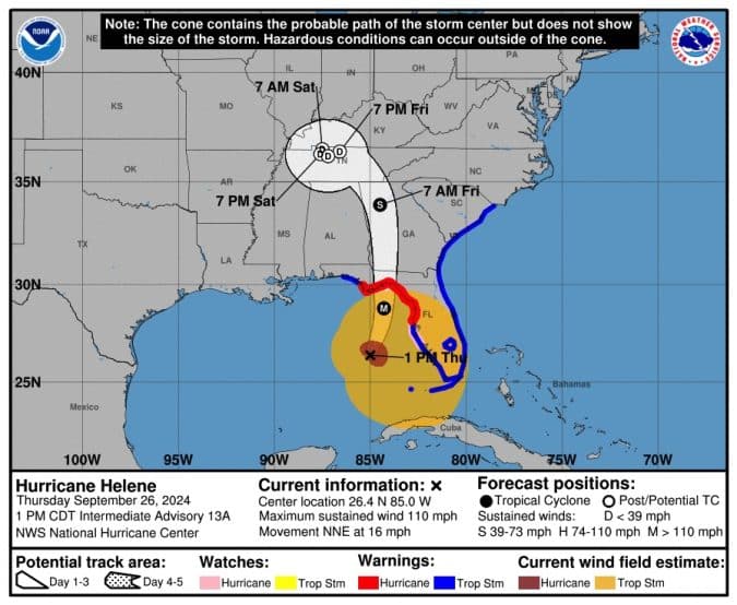
At 100 PM CDT (1800 UTC), the center of Hurricane Helene was located
near latitude 26.4 North, longitude 85.0 West. Helene is moving
toward the north-northeast near 16 mph (26 km/h). A significant
increase in forward speed is expected during the next 24 hours. On
the forecast track, Helene will make landfall in the Florida Big
Bend region this evening. After landfall, Helene is expected to turn
northwestward and slow down over the Tennessee Valley on Friday and
Saturday.
Maximum sustained winds have increased to near 110 mph (175 km/h)
with higher gusts. Additional strengthening is forecast, and Helene
is expected to be a major hurricane when it reaches the Florida Big
Bend coast this evening. Weakening is expected after landfall, but
Helene’s fast forward speed will allow strong, damaging winds,
especially in gusts, to penetrate well inland across the
southeastern United States, including over the higher terrain of the
southern Appalachians.
Helene is a very large hurricane. Hurricane-force winds extend
outward up to 60 miles (95 km) from the center and
tropical-storm-force winds extend outward up to 345 miles (555 km).
A weather station in Tarpon Point recently reported a sustained
wind of 41 mph (67 km/h) with a gust to 54 mph (87 km/h).
The minimum central pressure based on data from the Air Force
Hurricane Hunters is 959 mb (28.32 inches).
HAZARDS AFFECTING LAND
———————-
Key Messages for Helene can be found in the Tropical Cyclone
Discussion under AWIPS header MIATCDAT4 and WMO header WTNT44 KNHC
and on the web at hurricanes.gov/text/MIATCDAT4.shtml
STORM SURGE: The combination of a life-threatening storm surge and
the tide will cause normally dry areas near the coast to be flooded
by rising waters moving inland from the shoreline. The water could
reach the following heights above ground somewhere in the indicated
areas if the peak surge occurs at the time of high tide…
Carrabelle, FL to Suwannee River, FL…15-20 ft
Apalachicola, FL to Carrabelle, FL…10-15 ft
Suwannee River, FL to Chassahowitzka, FL…10-15 ft
Chassahowitzka, FL to Anclote River, FL…8-12 ft
Indian Pass, FL to Apalachicola, FL…6-10 ft
Anclote River, FL to Middle of Longboat Key, FL…5-8 ft
Tampa Bay…5-8 ft
Middle of Longboat Key, FL to Englewood, FL…4-7 ft
East of Mexico Beach, FL to Indian Pass, FL…3-5 ft
Englewood, FL to Flamingo, FL…3-5 ft
Charlotte Harbor…3-5 ft
The deepest water will occur along the immediate coast near and to
the east of the landfall location, where the surge will be
accompanied by large and dangerous waves. Surge-related flooding
depends on the relative timing of the surge and the tidal cycle,
and can vary greatly over short distances. For information
specific to your area, please see products issued by your local
National Weather Service forecast office.
For a complete depiction of areas at risk of storm surge inundation,
please see the National Weather Service Peak Storm Surge Graphic,
available at hurricanes.gov/graphics_at4.shtml?peakSurge.
WIND: Hurricane conditions are expected within the U.S. hurricane
warning area late today. Tropical storm conditions have
occurring in the Florida Keys and portions of southern and
southwestern Florida, and these conditions are expected to spread
northward across the tropical storm warning areas in the
southeastern U.S. through early Friday. Strong, damaging winds,
especially in gusts, will likely penetrate as far inland as the
higher terrain of the southern Appalachians.
RAINFALL: Hurricane Helene is expected to produce total rain
accumulations of 4 to 8 inches over western Cuba. This rainfall
brings a risk of considerable flooding.
Over portions of the Southeastern U.S. into the Southern
Appalachians, Helene is expected to produce total rain accumulations
of 6 to 12 inches, with isolated totals around 20 inches. This
rainfall will likely result in catastrophic and potentially
life-threatening flash and urban flooding, along with significant
river flooding. Numerous significant landslides are expected in
steep terrain across the southern Appalachians.
For a complete depiction of forecast rainfall associated with
Hurricane Helene, please see the National Weather Service Storm
Total Rainfall Graphic, available at
hurricanes.gov/graphics_at4.shtml?rainqpf and the Flash Flood Risk
graphic at hurricanes.gov/graphics_at4.shtml?ero.
For a list of rainfall observations (and wind reports) associated
this storm, see the companion storm summary at WBCSCCNS4 with the
WMO header ACUS44 KWBC or at the following link:
www.wpc.ncep.noaa.gov/discussions/nfdscc4.html.
TORNADOES: The risk for several tornadoes will gradually increase
today through tonight. The greatest threat is expected from parts of
northern Florida into southeast Georgia, the Midlands and Low
Country of South Carolina, and southern North Carolina.
SURF: Swells generated by Helene will affect much of Florida and
the coasts of Georgia and the Carolinas during the next couple of
days. Swells will also continue across portions of Cuba and the
Yucatan Peninsula through tonight. These swells are likely to cause
life-threatening surf and rip current conditions. Please consult
products from your local weather office.
NEXT ADVISORY
————-
Next complete advisory at 400 PM CDT.
—
Escambia County
Hurricane Helene Update #2
Hurricane Helene continues to strengthen this morning and is expected to become a major hurricane before making landfall near Tallahassee this evening, Thursday, Sept. 26, according to the U.S. National Weather Service. While Escambia County still remains outside of the track of the storm, residents are encouraged to remain weather aware.
The National Weather Service in Mobile, Alabama is projecting local impacts beginning today, including rip currents and high surf through Friday, Sept. 27.
NWS has issued the following advisories for Escambia County:
- A coastal flood advisory is in effect through early Friday afternoon. Minor coastal flooding is expected around times of high tide Thursday morning through early Friday afternoon along the coastal interface of Alabama and the western Florida panhandle.
- A wind advisory is in effect starting at noon today through midnight tonight, with sustained winds up to 15-25 mph and gusts up to 40 mph.
Up to 2 inches of rain with locally higher amounts is forecast across south central Alabama and the western Florida panhandle. Locally heavy rainfall in a short period of time could result in localized flooding of urban and low-lying areas.
Escambia County is mobilizing and deploying resources to assist areas of the state expected to be impacted by Hurricane Helene, standing ready to help neighboring counties and the state with storm preparation and recovery. Read more here.
Gov. Ron DeSantis issued Executive Order (EO) 24-209, Emergency Management – Amending Executive Order 24-208– Potential Tropical Cyclone Nine on Tuesday, Sept. 24, increasing the number of counties in the state of Florida under a state of emergency to 61, including Escambia, ahead of the storm.
Escambia County is offering sand for residents living in flood-prone areas. The sand is available on a first come, first served basis and locations are open 24 hours a day. Residents must bring their own sandbags and shovels to one of the following locations (map):
- Baars Field Athletic Park – 13001 Sorrento Road, Pensacola
- Brent Athletic Park – 4711 N. W St., Pensacola
- Don Sutton Park – 2320 Crabtree Church Road, Molino
- Equestrian Center – 7750 Mobile Highway, Pensacola
- Escambia County Road Department – 601 Highway 297-A, Pensacola
- Ferry Pass Middle School – 8355 Yancey Lane, Pensacola (sand will be on the northwest corner of school property on Parazine Street)
- John R. Jones Jr. Athletic Park – 555 E. Nine Mile Road, Pensacola
- Travis M. Nelson Park – 4541 County Road 4, Pensacola
Residents can sign up for Alert Escambia emergency updates through the Emergency Management website.