WATCHES AND WARNINGS
——————–
CHANGES WITH THIS ADVISORY:
The Tropical Storm Watch for the west coast of Florida has been
extended from Chokoloskee southward to Flamingo.
A Tropical Storm Watch has been issued for the Florida Keys from
Seven Mile Bridge eastward to the Channel 5 Bridge in the Middle
Keys.
A Tropical Storm Watch has been issued for Lake Okeechobee.
SUMMARY OF WATCHES AND WARNINGS IN EFFECT:
A Hurricane Warning is in effect for…
* Grand Cayman
* Cuban provinces of Isla de Juventud, Pinar del Rio, and Artemisa
A Tropical Storm Warning is in effect for…
* Cuban provinces of La Habana, Mayabeque, and Matanzas
* Lower Florida Keys from Seven Mile Bridge westward to Key West
* Dry Tortugas
A Storm Surge Watch is in effect for…
* Florida Keys from the Card Sound Bridge westward to Key West
* Dry Tortugas
* Florida Bay
* Anclote River southward to the Card Sound Bridge
* Tampa Bay
A Hurricane Watch is in effect for…
* Englewood to the Anclote River, including Tampa Bay
A Tropical Storm Watch is in effect for…
* Little Cayman and Cayman Brac
* Englewood southward to Flamingo
* Florida Keys from Seven Mile Bridge to the Channel 5 Bridge
* Lake Okeechobee
DISCUSSION AND OUTLOOK
———————-
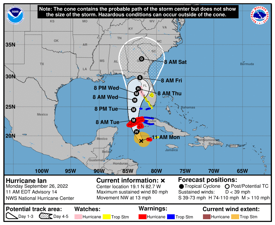
At 1100 AM EDT (1500 UTC), the center of Hurricane Ian was located
near latitude 19.1 North, longitude 82.7 West. Ian is moving toward
the northwest near 13 mph (20 km/h). A north-northwestward motion is
expected to begin later today, followed by a northward motion on
Tuesday with a slightly slower forward speed. A turn toward the
north-northeast with a further reduction in forward speed is
forecast on Wednesday. On the forecast track, the center of Ian is
expected to pass near or west of the Cayman Islands today, and near
or over western Cuba tonight and early Tuesday. Ian will then emerge
over the southeastern Gulf of Mexico on Tuesday, pass west of the
Florida Keys late Tuesday, and approach the west coast of Florida on
Wednesday into Thursday.
Maximum sustained winds have increased to near 80 mph (130 km/h)
with higher gusts. Rapid strengthening is expected during the next
day or so, and Ian is forecast to become a major hurricane tonight
or early Tuesday when it is near western Cuba and remain a major
hurricane over the southeastern Gulf of Mexico on Wednesday.
Hurricane-force winds extend outward up to 25 miles (35 km) from the
center and tropical-storm-force winds extend outward up to 115 miles
(185 km).
The minimum central pressure based on Air Force and NOAA Hurricane
Hunter aircraft data is 980 mb (28.94 inches).