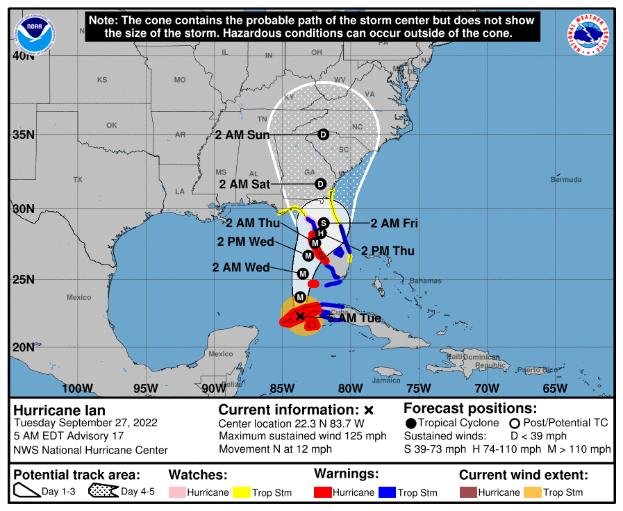
The storm appears to be heading to the Tampa/St. Pete area.
Hurricane Ian Advisory Number 17
NWS National Hurricane Center Miami FL AL092022
500 AM EDT Tue Sep 27 2022
…CATEGORY 3 HURRICANE IAN MOVING OVER WESTERN CUBA…
…SIGNIFICANT WIND AND STORM SURGE IMPACTS OCCURRING OVER WESTERN
CUBA…
SUMMARY OF 500 AM EDT…0900 UTC…INFORMATION
———————————————-
LOCATION…22.3N 83.7W
ABOUT 5 MI…10 KM S OF THE CITY OF PINAR DEL RIO CUBA
ABOUT 175 MI…280 KM SSW OF THE DRY TORTUGAS
MAXIMUM SUSTAINED WINDS…125 MPH…205 KM/H
PRESENT MOVEMENT…N OR 355 DEGREES AT 12 MPH…19 KM/H
MINIMUM CENTRAL PRESSURE…952 MB…28.12 INCHES
WATCHES AND WARNINGS
——————–
CHANGES WITH THIS ADVISORY:
The Hurricane Warning has been extended southward along the west
coast of Florida to Bonita Beach
A Tropical Storm Warning has been issued for the Middle Florida
Keys from the Channel 5 Bridge westward to the Seven Mile Bridge.
A Tropical Storm Warning has been issued for the west coast of
Florida from the Anclote River northward to the Suwannee River.
A Tropical Storm Warning has been issued along the east coast of
Florida from Jupiter Inlet to the Volusia/Brevard County Line
including Lake Okeechobee.
A Tropical Storm Watch has been issued for southeast coast of
Florida from Deerfield Beach northward to Jupiter Inlet.
SUMMARY OF WATCHES AND WARNINGS IN EFFECT:
A Hurricane Warning is in effect for…
* Cuban provinces of Isla de Juventud, Pinar del Rio, and Artemisa
* Bonita Beach to the Anclote River, including Tampa Bay
* Dry Tortugas
A Storm Surge Warning is in effect for…
* Anclote River southward to Flamingo
* Tampa Bay
A Tropical Storm Warning is in effect for…
* Cuban provinces of La Habana, Mayabeque, and Matanzas
* Lower Florida Keys from Seven Mile Bridge westward to Key West
* Flamingo to Bonita Beach
* Suwannee River to the Anclote River
* Volusia/Brevard County Line south to Jupiter Inlet
* Lake Okeechobee
A Storm Surge Watch is in effect for…
* Florida Keys from the Card Sound Bridge westward to Key West
* Dry Tortugas
* Florida Bay
* Aucilla River to Anclote River
* Altamaha Sound to Flagler/Volusia County Line
* Saint Johns River
A Hurricane Watch is in effect for…
* North of Anclote River to the Suwannee River
DISCUSSION AND OUTLOOK
———————-
At 500 AM EDT (0900 UTC), the center of Hurricane Ian was located near latitude 22.3 North, longitude 83.7 West. Ian is moving toward the north near 12 mph (19 km/h), and this motion is expected to continue today.
A turn toward the north-northeast with a reduction in forward speed is forecast tonight and Wednesday. On the forecast track, the center of Ian is expected to move over western Cuba during the next few hours. Ian will then emerge over the southeastern Gulf of Mexico later this morning, pass west of the Florida Keys later today, and approach the west coast of Florida within the hurricane warning area on Wednesday and Wednesday night.
Maximum sustained winds are near 125 mph (205 km/h) with higher gusts. Ian is a category 3 hurricane on the Saffir-SimpsonHurricane Wind Scale. Little change in strength is expected while Ian moves over Cuba. Strengthening is expected later this morning after Ian emerges over the southeastern Gulf of Mexico.
Ian is forecast to approach the west coast of Florida has a major hurricane.
Hurricane-force winds extend outward up to 35 miles (55 km) from the center and tropical-storm-force winds extend outward up to 115 miles (185 km).
The estimated minimum central pressure is 952 mb


