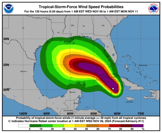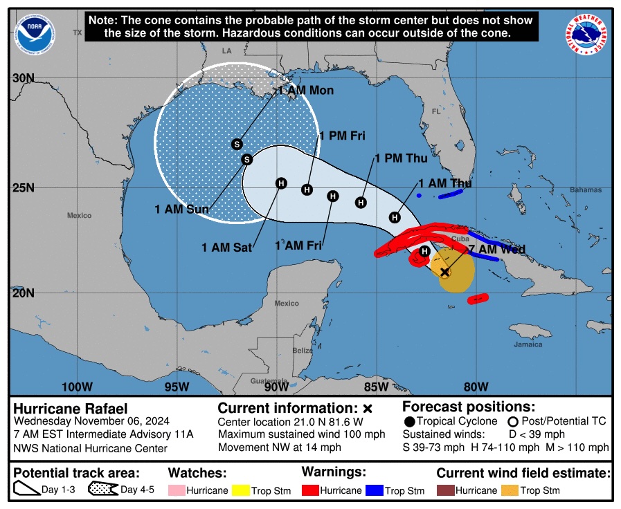
Escambia County Public Safety Director Eric Gilmore says the models have aligned, and we are out of the cone of uncertainty.
“We do have a lot of factors in the Gulf, so we got the cooler waters. We’re going to have some wind shear, but the whole time the European (model) has had this thing get into the Gulf, kind of meander around it and take a western turn. Well, this morning GSS is agreeing with the European that it’s going to take a Western turn, so we should not see any impact from the storm.”

BULLETIN
Hurricane Rafael Intermediate Advisory Number 11A
NWS National Hurricane Center Miami FL AL182024
700 AM EST Wed Nov 06 2024
…RAFAEL CONTINUES TO STRENGTHEN…
…EXPECTED TO BE NEAR MAJOR HURRICANE INTENSITY AT LANDFALL
IN WESTERN CUBA…
SUMMARY OF 700 AM EST…1200 UTC…INFORMATION
———————————————-
LOCATION…21.0N 81.6W
ABOUT 90 MI…140 KM ESE OF THE ISLE OF YOUTH
ABOUT 160 MI…260 KM SSE OF HAVANA CUBA
MAXIMUM SUSTAINED WINDS…100 MPH…160 KM/H
PRESENT MOVEMENT…NW OR 315 DEGREES AT 14 MPH…22 KM/H
MINIMUM CENTRAL PRESSURE…964 MB…28.47 INCHES
WATCHES AND WARNINGS
——————–
CHANGES WITH THIS ADVISORY:
The government of the Cayman Islands has discontinued the Hurricane
Warning for Grand Cayman.
The government of Cuba has discontinued the Tropical Storm Watch
for the Cuban provinces of Camaguey and Las Tunas.
SUMMARY OF WATCHES AND WARNINGS IN EFFECT:
A Hurricane Warning is in effect for…
* Little Cayman and Cayman Brac
* Cuban provinces of Pinar del Rio, Artemisa, La Habana, Mayabeque,
Matanzas, and the Isle of Youth
A Tropical Storm Warning is in effect for…
* Cuban provinces of Villa Clara, Cienfuegos, Sancti Spiritus,
and Ciego de Avila
* Lower and Middle Florida Keys from Key West to west of the
Channel 5 Bridge
* Dry Tortugas
A Hurricane Warning means that hurricane conditions are expected
somewhere within the warning areas. Preparations to protect life
and property should be rushed to completion.
A Tropical Storm Warning means that tropical storm conditions are
expected somewhere within the warning area.
For storm information specific to your area in the United
States, including possible inland watches and warnings, please
monitor products issued by your local National Weather Service
forecast office. For storm information specific to your area
outside of the United States, please monitor products issued by
your national meteorological service.
DISCUSSION AND OUTLOOK
———————-
At 700 AM EST (1200 UTC), the eye of Hurricane Rafael was located
near latitude 21.0 North, longitude 81.6 West. Rafael is moving
toward the northwest near 14 mph (22 km/h). A general northwestward
motion is anticipated over the next day or two, followed by a
gradual west-northwestward turn in the Gulf of Mexico. On the
forecast track, Rafael is expected move near or over the Isle of
Youth later this morning or early this afternoon, and make landfall
in western Cuba later today. Rafael is forecast to move into the
southeastern Gulf of Mexico tonight.
Reports from a NOAA Hurricane Hunter aircraft indicate that the
maximum sustained winds have increased to near 100 mph (160 km/h)
with higher gusts. Rapid strengthening is forecast, and Rafael
could be near major hurricane intensity before it makes landfall in
Cuba later today. Rafael is forecast to weaken over Cuba but is
expected to emerge into the southeastern Gulf of Mexico as a
hurricane.
Hurricane-force winds extend outward up to 15 miles (30 km) from
the center and tropical-storm-force winds extend outward up to 105
miles (165 km).
The minimum central pressure estimated from Air Force Hurricane
Hunter aircraft observations is 964 mb (28.47 inches).


