The storm is heading straight for us. How fierce it will be has yet to be determined. Â Best info currently: Tropical Storm force winds that will start to see tomorrow. The storm is expected to make landfill early Tuesday morning.
From NOAA: The area of troughing/low pressure in the eastern Gulf of Mexico that once was Tropical Storm Fred is expected to redevelop into a tropical storm later today.
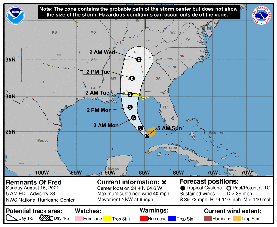
Fred is then expected to move northwestward and northward through the Gulf and is currently forecast to make landfall somewhere in the central Gulf Coast around Monday evening. Heavy rainfall and gusty winds can be expected along its track.
Most of the rain may stay offshore of Florida today and tonight if the system takes a western track away from the Florida Gulf Coast, but by Monday into Tuesday, very heavy rain should begin over the Florida Panhandle and the Southeast. Slight Risks of excessive rainfall are in place for the scattered flash flooding threat.
WATCHES AND WARNINGS
——————–
CHANGES WITH THIS ADVISORY:
A Tropical Storm Watch has been issued for portions of the north-central Gulf coast from the Alabama/Florida border eastward to Ochlockonee River, Florida.
A Tropical Storm Watch means that tropical storm conditions are possible within the watch area, generally within 48 hours.
Interests along the northern coast of the Gulf of Mexico from Alabama to the central Florida Panhandle should monitor the progress of the remnants of Fred. A Tropical Storm Warning will likely be required for portions of the Tropical Storm Watch area later this morning.
For storm information specific to your area, including possible inland watches and warnings, please monitor products issued by your local National Weather Service forecast office.
RAINFALL:
The system is expected to produce the following rainfall amounts:
Through Monday:Â Keys and southern Florida… 3 to 5 inches with isolated storm totals of 8 inches are anticipated.
Through Tuesday:Â The Florida Big Bend and Panhandle… 4 to 8 inches with isolated maximum storm totals of 12 inches are expected.
South-Central and Southeast Alabama through Georgia and the Western Carolinas… 3 to 6 inches with isolated maximum storm totals of 9 inches are expected due to the combination of Fred and a preceding frontal boundary.
Heavy rainfall across portions of Florida, southern Alabama, portions of Georgia, and the western Carolinas could lead to areal, urban, small stream and river flooding impacts.
STORM SURGE: A storm surge will raise water levels above normal tide by as much as the following amounts in areas of onshore flow… Mouth of the Pearl River, LA to Suwannee River, FL including Mobile Bay, Pensacola Bay, Choctawhatchee Bay and Saint Andrew Bay… 1-3 ft
Surge-related flooding depends on the relative timing of the surge and the tidal cycle, and can vary greatly over short distances. For information specific to your area, please see products issued by your local National Weather Service forecast office.
WIND: Tropical storm conditions are possible within the watch area by late Monday night or Tuesday morning.
SURF: Swells generated by Fred or its remnants are expected to spread across the Florida Keys later this morning and reach the coast of Mississippi, Alabama and the Florida Panhandle on Monday. Please consult products from your local weather office for more details.
TORNADOES: A tornado or two will be possible today into early Monday, near the west coast of Florida and the coastal Florida Panhandle.