

4 a.m. Key Messages for Hurricane Isaias
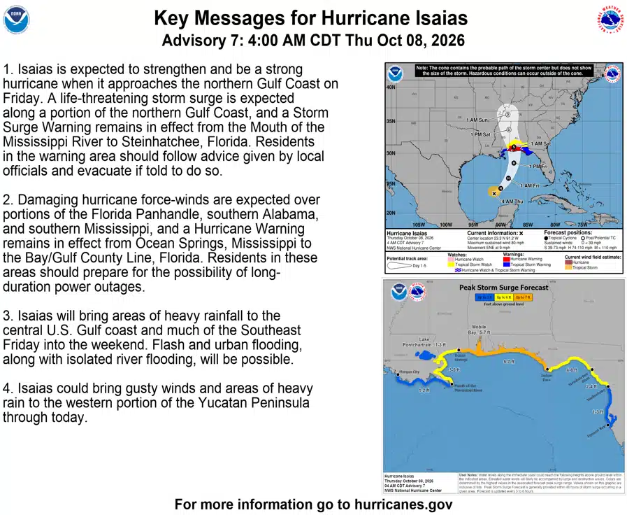
7 a.m. Thursday NOAA Hurricane Center Advisory
BULLETIN
Hurricane Isaias Intermediate Advisory Number 7A
NWS National Hurricane Center Miami FL AL092026
700 AM CDT Thu Oct 08 2026
…HURRICANE HUNTERS CURRENTLY INVESTIGATING ISAIAS…
…PREPARATIONS TO PROTECT LIFE AND PROPERTY FROM STORM SURGE AND
DAMAGING WINDS ALONG THE WARNING AREA OF THE GULF COAST SHOULD BE
RUSHED TO COMPLETION TODAY…
SUMMARY OF 700 AM CDT…1200 UTC…INFORMATION
———————————————-
LOCATION…23.7N 90.6W
ABOUT 175 MI…280 KM NNW OF PROGRESO MEXICO
ABOUT 385 MI…620 KM SSW OF THE MOUTH OF THE MISSISSIPPI RIVER
MAXIMUM SUSTAINED WINDS…80 MPH…130 KM/H
PRESENT MOVEMENT…ENE OR 60 DEGREES AT 9 MPH…15 KM/H
MINIMUM CENTRAL PRESSURE…975 MB…28.80 INCHES
WATCHES AND WARNINGS
——————–
CHANGES WITH THIS ADVISORY:
None.
SUMMARY OF WATCHES AND WARNINGS IN EFFECT:
A Storm Surge Warning is in effect for…
* Mouth of the Mississippi River to the Steinhatchee River, FL
A Hurricane Warning is in effect for…
* Ocean Springs, MS to the Bay/Gulf County Line, FL
A Tropical Storm Warning is in effect for…
* Jefferson/Plaquemines Parish Line, LA to west of Ocean Springs, MS
* East of Bay/Gulf County Line to Aucilla River, FL
A Storm Surge Watch is in effect for…
* Steinhatchee River to Yankeetown, FL
A Storm Surge Warning means there is a danger of life-threatening
inundation, from rising water moving inland from the coastline,
during the next 36 hours in the indicated locations. For a depiction
of areas at risk, please see the National Weather Service Storm
Surge Watch/Warning Graphic, available at hurricanes.gov. This is a
life-threatening situation. Persons located within these areas
should take all necessary actions to protect life and property from
rising water and the potential for other dangerous conditions.
Promptly follow evacuation and other instructions from local
officials.
A Hurricane Warning means that hurricane conditions are expected
somewhere within the warning area. A warning is typically issued 36
hours before the anticipated first occurrence of
tropical-storm-force winds, conditions that make outside
preparations difficult or dangerous. Preparations to protect life
and property should be rushed to completion.
A Tropical Storm Warning means that tropical storm conditions are
expected somewhere within the warning area within 36 hours.
A Storm Surge Watch means there is a possibility of life-
threatening inundation, from rising water moving inland from the
coastline, in the indicated locations during the next 48 hours. For
a depiction of areas at risk, please see the National Weather
Service Storm Surge Watch/Warning Graphic, available at
hurricanes.gov.
Interests in the Yucatan Peninsula of Mexico and elsewhere along the
U.S. northern Gulf Coast should closely monitor the progress of this
system.
For storm information specific to your area, including possible
inland watches and warnings, please monitor products issued by your
local National Weather Service forecast office.
DISCUSSION AND OUTLOOK
———————-
At 700 AM CDT (1200 UTC), the center of Hurricane Isaias was located
near latitude 23.7 North, longitude 90.6 West. Isaias is moving
toward the east-northeast near 9 mph (15 km/h). A turn toward the
northeast is expected later today followed by a turn northward on
Friday. On the forecast track, Isaias is expected to pass to the
north of the Yucatan Peninsula later today and make landfall along
the U.S. northern Gulf Coast within the warning area late Friday or
early Saturday.
Maximum sustained winds are near 80 mph (130 km/h) with higher
gusts. Additional strengthening is expected through early Friday,
and Isaias should remain a dangerous hurricane as it approaches the
northern Gulf Coast Friday night.
Hurricane-force winds extend outward up to 15 miles (30 km) from
the center and tropical-storm-force winds extend outward up to 90
miles (150 km).
The estimated minimum central pressure is 975 mb (28.80 inches).
HAZARDS AFFECTING LAND
———————-
Key messages for Isaias can be found in the Tropical Cyclone
Discussion under AWIPS header MIATCDAT4 and WMO header WTNT44 KNHC.
STORM SURGE: The combination of a dangerous storm surge and the
tide will cause normally dry areas near the coast to be flooded by
rising waters moving inland from the shoreline. The water could
reach the following heights above ground somewhere in the indicated
areas if the peak surge occurs at the time of high tide…
Ocean Springs, MS to Indian Pass, FL…5-7 ft
Mobile Bay…5-7 ft
Mouth of the Mississippi River, LA to Ocean Springs, MS…3-5 ft
Indian Pass, FL to Steinhatchee River, FL…4-6 ft
Steinhatchee River, FL to Yankeetown, FL…2-4 ft
Lake Pontchartrain…1-3 ft
The deepest water will occur along the immediate coast near and to
the east of the landfall location, where the surge will be
accompanied by large and dangerous waves. Surge-related flooding
depends on the relative timing of the surge and the tidal cycle, and
can vary greatly over short distances. For information specific to
your area, please see products issued by your local National Weather
Service forecast office.
For a complete depiction of areas at risk of storm surge inundation,
please see the National Weather Service Peak Storm Surge Graphic,
available at hurricanes.gov/graphics_at4.shtml?peakSurge.
WIND: Hurricane conditions are expected within the Hurricane Warning
area Friday night into early Saturday, with tropical storm
conditions beginning on Friday. Tropical storm conditions are
expected in the warning areas on Friday and Friday night.
Gusty winds are possible in portions of the Yucatan Peninsula today.
RAINFALL: Isaias is expected to produce rainfall amounts of 1 to 3
inches through today across coastal portions of the eastern Bay
of Campeche with isolated higher amounts possible in the states of
Campeche and western Yucatan.
From Friday through the weekend, the system is expected to produce
rainfall amounts of 3 to 7 inches, with localized totals up to 10
inches, across the central U.S. Gulf Coast extending from far
southeastern Louisiana to the Florida Panhandle. Rainfall amounts of
1 to 3 inches, with localized amounts up to 5 inches, are possible
across much of the Southeast as far north as the Tennessee Valley
and the Carolinas. Flash and urban flooding, along with isolated
river flooding, will be possible.
For a complete depiction of forecast rainfall associated with
Isaias, please see the National Weather Service Storm Total Rainfall
Graphic available at hurricanes.gov/graphics_at4.shtml?rainqpf and
the Flash Flood Risk graphic at
hurricanes.gov/graphics_at4.shtml?ero
TORNADOES: Isolated tornadoes will be possible Friday night in
coastal areas of Alabama and the Florida Panhandle and far
southwestern Georgia. The tornado threat will continue Saturday for
eastern Alabama, Georgia and northern Florida.
SURF: Swells will affect the western and northern portions of the
Yucatan Peninsula beginning later today and spread northward toward
the Gulf Coast on Friday. These swells are likely to cause
life-threatening surf and rip current conditions. Please consult
products from your local weather office.
A depiction of rip current risk for the United States can be found
at: hurricanes.gov/graphics_at4.shtml?ripCurrents
NEXT ADVISORY
————-
Next complete advisory at 1000 AM CDT.
Escambia County Schools
Escambia County Public Schools Superintendent Keith Leonard has announced that schools and district offices will be closed on Friday, October 9, 2026, due to impending severe weather associated with Isaias.
The National Weather Service forecast indicates severe weather moving through the area on Friday, with the possibility of heavy precipitation and hazardous winds. In an abundance of caution, all schools, district offices, and afterschool activities, including indoor and outdoor athletics, have been canceled for Friday, October 9, 2026.
“Although Monday, October 12 is a holiday for our students, we anticipate all other departments will resume work as usual on Monday,” stated Superintendent Keith Leonard. “Of course, we’ll continue to work closely with local emergency operations officials to determine what is safest for our families and staff. We will always err on the side of caution when it comes to the safety of our students and employees.”
District officials will continue to monitor weather updates, and members of the community are encouraged to do the same. If necessary, updates will be provided through local media, Focus Messenger, and the district website and social media platforms.
Santa Rosa County Schools
In consultation and coordination with Santa Rosa County Emergency Management and the National Weather Service in Mobile, Santa Rosa County District Schools is sharing the following important information regarding Tropical Storm Isaias.
Out of an abundance of caution, and with the safety of our students, employees, and families as our highest priority, all Santa Rosa County District Schools and offices will be closed Thursday, October 8th, and Friday, October 9th.
All school-sponsored activities, including athletic events, practices, clubs, meetings, and other extracurricular activities, are canceled for Thursday, October 8th, Friday, October 9th, and Saturday, October 10th.
We understand that changes to school schedules can create challenges for our families, and we appreciate your patience, flexibility, and understanding as we prioritize the safety of our school community.
The district will continue to monitor conditions and will communicate any additional updates through our official communication channels. Families and employees are encouraged to monitor district messages for the latest information.
Escambia County Office Closures for Tropical Storm Isaias
Escambia County offices will close Thursday, Oct. 8 starting at 2 p.m. and remain closed Friday, Oct. 9 due to Tropical Storm Isaias. Essential employees such as first responders and emergency response personnel will continue working throughout the storm.
The Emergency Operations Center will be activated at a Level 2 Thursday, Oct. 8 and at a Level 1 Friday, Oct. 9.
Office Closures Include:
- Escambia County Board of County Commissioners – All departments
- West Florida Public Libraries – All locations
- Escambia County Tax Collector – All offices
- Escambia County Supervisor of Elections Office
- Escambia County Property Appraiser’s Office – Both locations
- Waste Services Administration
- Escambia County Extension Services
- Escambia County Clerk of the Court and Comptroller – All offices
- Escambia County Department of Animal Welfare
- Escambia County Area Transit and Customer Service
Animal Welfare Schedule:
- The Department of Animal Welfare will also be closed Saturday, Oct. 10.
Building Services Inspections Schedule:
- Escambia County Building Services will not perform any inspections Friday, Oct. 9.
ECAT Bus Schedule:
- ECAT administrative offices will be closed starting at 2 p.m. Thursday, Oct. 8 and remain closed Friday, Oct. 9.
- ECAT buses, FlexTransit, and the UWF trolleys will not runThursday, Oct. 8, Friday, Oct. 9, or Saturday, Oct. 10.
- Transportation for dialysis, medical appointments, and other life-sustaining trips are being coordinated and rescheduled directly with each facility.
West Florida Public Libraries Schedule:
- All WFPL locations will also be closed Saturday, Oct. 10.
Waste Services Schedule:
- The Palafox Transfer Station and Perdido Landfill will be open with regular hours Friday, Oct. 9, weather permitting.
- The Oak Grove Transfer Station will be closed Friday, Oct. 9 and Saturday, Oct. 10.
Escambia County Public Schools
- Escambia County Public Schools will also be closed Friday, Oct. 9 due to Tropical Storm Isaias. Click here to read more.
For information about closures or cancelations from other agencies, please monitor their websites and social media pages.
Residents are encouraged to remain weather aware and continue monitoring the forecast for updates. Ensure you have multiple ways to receive warnings and know your safe place ahead of time.
ECUA
The Emerald Coast Utilities Authority Customer Service Department will be closed Friday, Oct. 9, as a precautionary measure due to the potential impacts of Tropical Storm Isaias. The closure is beingmade out of an abundance of caution to help protect ECUA customers and employees as the storm approaches the area.
Customers experiencing a utility emergency may also call ECUA’s emergency after-hours line at (850)
476-5110.
ECUA will continue to monitor the storm and provide updates as necessary. For the latest information from ECUA, customers are encouraged to visit ECUA.fl.gov and follow ECUA on social media.
Court System
ESCAMBIA COUNTY
Escambia County courthouses will close at 2 p.m. on Thursday, October 8 and remain closed on Friday, October 9.
Felony Arraignments scheduled for Friday, October 9 will be reset to Friday, October 16, 2026, at 8:30 a.m.
Civil Traffic Infraction Hearings scheduled on Friday, October 9 will be reset to Friday, October 23, 2026, at 9 a.m.
First Appearances previously scheduled on Friday, October 9 at 10:30 a.m. will be heard Friday, October 9 at 8 a.m. at the Juvenile Justice Center.
Pre-Trial Detention Hearings previously scheduled on Friday, October 9 at 11 a.m. will be heard Friday, October 9 at 9 a.m. at the Juvenile Justice Center.
All other hearings will be reset by the assigned judge.
SANTA ROSA COUNTY
The Santa Rosa County Courthouse will close at 2:30 on Thursday, October 8 and will remain closed on Friday, October 9.
Pensacola State College
UWF
All classes at the Pensacola campus, Fort Walton Beach campus and online are canceled beginning Thursday, Oct. 8, 2026. All UWF locations, including the Pensacola campus, Fort Walton Beach campus and UWF Historic Trust, will close Thursday, Oct. 8 at 7 p.m. This includes all classes, events and campus activities. Nonessential personnel, as defined by your division head, do not need to report to campus on Thursday, Oct. 8.
Football Game
Due to the incoming weather from Tropical Storm Isaias, Saturday’s home football game against Northeastern State has been canceled.
The athletics department in partnership with UWF leadership made the decision on Wednesday afternoon out of an abundance of caution for the safety of the campus and Pensacola community.
Ice Flyers Season Ticket Pick-up
Dear Season Ticket Holders,
Due to preparations for severe weather, we are canceling season ticket holder pickup scheduled for tomorrow, Thursday, October 8, and Friday, October 9. The safety of our fans and staff is our priority, and we appreciate your understanding.
Pickup is scheduled to resume next week:
-
Monday, October 12: 10:00 AM–4:00 PM
-
Tuesday, October 13: 10:00 AM–4:00 PM
-
Wednesday, October 14: 10:00 AM–4:00 PM, with additional evening pickup from 5:00–7:00 PM
-
Thursday, October 15: 10:00 AM–4:00 PM
For pickup between 10:00 AM and 4:00 PM, please use the front entrance of the Bay Center. An Ice Flyers representative will be there with your season ticket items.
For Wednesday’s evening pickup from 5:00 to 7:00 PM, please visit the Ice Flyers office at the back of the Bay Center.
We’ll keep you informed if severe weather affects next week’s schedule. Please stay safe, and thank you for your continued support!
Baseball
BLUE WAHOOS CANCEL FLORIDA STATE, AUBURN FALL BASEBALL
EXHIBITION DUE TO TROPICAL STORM ISAIAS
PENSACOLA, FL – The Pensacola Blue Wahoos announced Wednesday that the fall baseball exhibition between the Florida State Seminoles and Auburn Tigers scheduled for Saturday, October 10 has been canceled due to the potential for severe weather along the Gulf Coast this weekend.
The game will not be rescheduled. Fans with tickets to Saturday’s game can either receive a ticket of equal or lesser value to upcoming fall college baseball exhibitions on October 17 (Alabama vs. Georgia Tech) or October 24 (Florida vs. Troy). In service of making the fan experience a priority, refunds are also available. Ticket holders are encouraged to call the ticket office at (850) 934-8444 for expedited service.
Gulf Breeze Zoo
Gulf Breeze Zoo will be closed Friday, October 9 through Sunday, October 11, due to the anticipated impacts of Tropical Storm Isaias. The closure will allow Zoo staff to prepare the park and animals ahead of the storm and keep guests and team members safely off property as severe weather approaches.
As a result, the opening weekend of Boo at the Zoo, scheduled for October 10 and 11, has been canceled. Tickets already purchased for this weekend may be used on any remaining Boo at the Zoo date.
“The safety of our animals, guests and team members is our highest priority,” said Hunter Hullett, Gulf Breeze Zoo Director. “Closing on Friday gives our team the time needed to prepare the Zoo ahead of the storm. We know families have been looking forward to the first weekend of Boo at the Zoo, and we’re disappointed to cancel, but we look forward to welcoming everyone back for Halloween fun next weekend.”
Boo at the Zoo will now begin Saturday, October 17, with event dates scheduled for October 17–18, October 24–25 and Saturday, October 31.
The Halloween-day finale will give families a special opportunity to celebrate on Saturday, October 31, with daytime trick-or-treating at the Zoo.
OWA
For the safety of our team members, guests, and businesses, operations of Tropic Falls and Downtown OWA, will be closed Friday, October 9, and Saturday, October 10, due to Tropical Storm Isaias.
Guests who have already purchased tickets for Tropic Falls or Primal Fear for Friday, October 9, or Saturday, October 10, please contact guest services by email at tropicfallsgs@visitowa.com to reschedule for a future visit.
Waterfront Mission
First City Art Center – Pumpkin Patch: Rescheduled to Oct. 23-24. https://firstcityart.org/
Ssanta Rosa Isla Triathlon – Canceled
Friends of te West Florida Public Library Book Sale – Postponed
BRACE Storms & Stars Soiree – Canceled