The 2024 Atlantic hurricane season is likely to be extremely active, according to the U.S. government’s official seasonal outlook released today.
“This season is looking to be an extraordinary one in a number of ways,” said NOAA administrator Rick Spinrad in a press conference this morning. The agency’s forecast is the most aggressive hurricane season outlook that NOAA has ever issued in May.
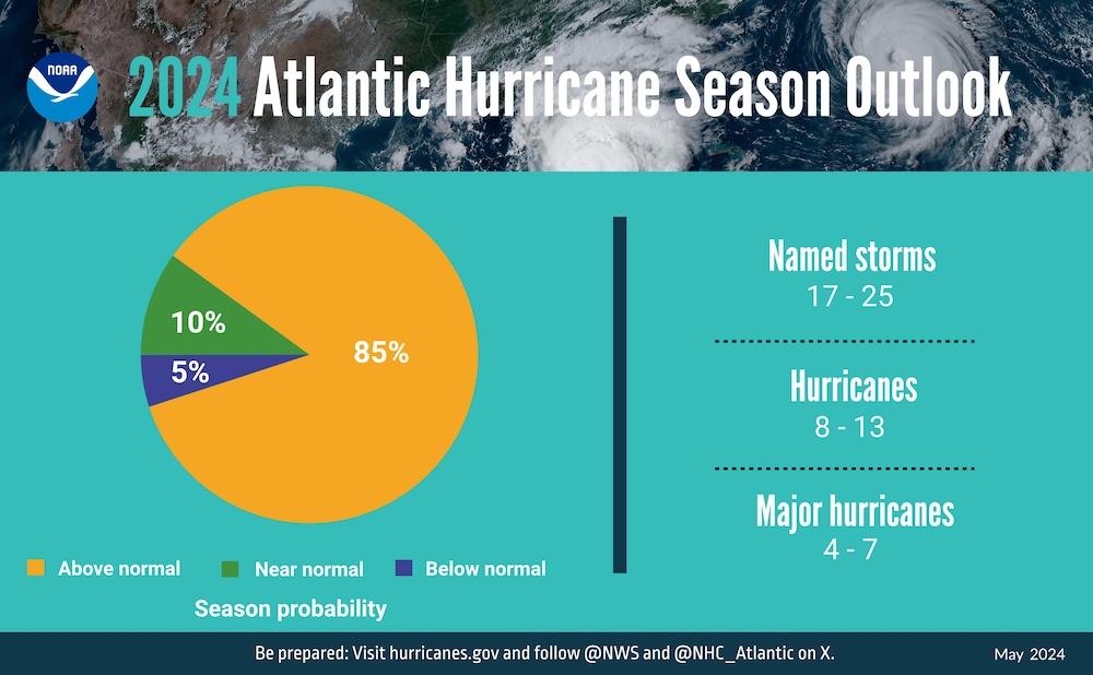
- NOAA’s outlook for the 2024 Atlantic hurricane season, which spans from June 1 to Nov. 30, predicts an 85% chance of an above-normal season, a 10% chance of a near-normal season, and a 5% chance of a below-normal season.
- NOAA is forecasting a range of 17 to 25 total named storms (winds of 39 mph or higher). Of those, 8 to 13 are forecast to become hurricanes (winds of 74 mph or higher), including 4 to 7 major hurricanes (category 3, 4 or 5 – with winds of 111 mph or higher). Forecasters have a 70% confidence in these ranges.

Why: The upcoming Atlantic hurricane season is expected to have above-normal activity due to a confluence of factors, including near-record warm ocean temperatures in the Atlantic Ocean, development of La Nina conditions in the Pacific, reduced Atlantic trade winds and less wind shear, all of which tend to favor tropical storm formation.
“Severe weather and emergencies can happen at any moment, which is why individuals and communities need to be prepared today,” said FEMA Deputy Administrator Erik A. Hooks. “Already, we are seeing storms move across the country that can bring additional hazards like tornadoes, flooding and hail. Taking a proactive approach to our increasingly challenging climate landscape today can make a difference in how people can recover tomorrow.”
New Tools:
Two new forecast models developed by NOAA researchers will go into operation this season: The Modular Ocean Model or MOM6 will be added to the Hurricane Analysis and Forecast System to improve the representation of the key role the ocean plays in driving hurricane intensity. Another model, SDCON, will predict the probability of tropical cyclone rapid intensification.
NOAA’s new generation of Flood Inundation Mapping will provide information to emergency and water managers to prepare and respond to potential flooding and help local officials better prepare to protect people and infrastructure.
NOAA’s Weather Prediction Center, in partnership with the NHC, will issue an experimental rainfall graphic for the Caribbean and Central America during the 2024 hurricane season. This graphic provides forecast rainfall totals associated with a tropical cyclone or disturbance for a specified time period.


