

I will post the NOAA Hurricane Center advisories here throughout the day:
BULLETIN
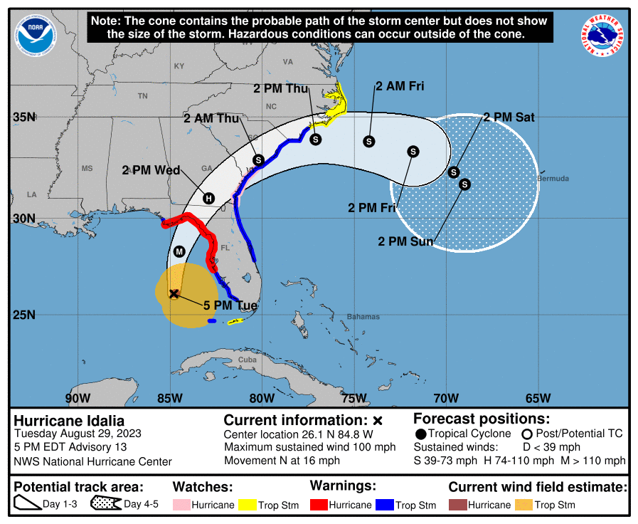
Hurricane Idalia Advisory Number 13…Corrected
NWS National Hurricane Center Miami FL AL102023
500 PM EDT Tue Aug 29 2023
Corrected Tropical Storm Warning area
…IDALIA NOW A CATEGORY 2 HURRICANE…
…LIFE-THREATENING STORM SURGE AND HURRICANE CONDITIONS EXPECTED
ALONG PORTIONS OF THE GULF COAST OF FLORIDA TONIGHT AND WEDNESDAY…
SUMMARY OF 500 PM EDT…2100 UTC…INFORMATION
———————————————-
LOCATION…26.1N 84.8W
ABOUT 195 MI…310 KM SW OF TAMPA FLORIDA
ABOUT 300 MI…480 KM S OF TALLAHASSEE FLORIDA
MAXIMUM SUSTAINED WINDS…100 MPH…155 KM/H
PRESENT MOVEMENT…N OR 360 DEGREES AT 16 MPH…26 KM/H
MINIMUM CENTRAL PRESSURE…972 MB…28.71 INCHES
WATCHES AND WARNINGS
——————–
CHANGES WITH THIS ADVISORY:
A Hurricane Watch has been issued from the mouth of the St. Mary’s
River northward to Edisto Beach.
A Storm Surge Watch has been issued from Beaufort Inlet to Drum
Inlet, North Carolina, as well as the Neuse and Pamlico Rivers.
A Tropical Storm Warning has been issued from South Santee River
northward to Surf City, North Carolina. A Tropical Storm Watch has
been issued north of Surf City to the North Carolina/Virginia
border, including Pamlico and Albemarle Sounds.
The Hurricane Watch from Englewood to the Middle of Longboat Key
has been discontinued.
The Storm Surge Watch has been discontinued south of Bonita Beach,
Florida.
SUMMARY OF WATCHES AND WARNINGS IN EFFECT:
A Storm Surge Warning is in effect for…
* Englewood northward to Indian Pass, including Tampa Bay
A Hurricane Warning is in effect for…
* Middle of Longboat Key northward to Indian Pass, including Tampa
Bay
A Tropical Storm Warning is in effect for…
* Dry Tortugas Florida
* Chokoloskee northward to the Middle of Longboat Key
* West of Indian Pass to Mexico Beach
* Sebastian Inlet Florida to Surf City North Carolina
A Storm Surge Watch is in effect for…
* Bonita Beach northward to Englewood, including Charlotte Harbour
* Mouth of the St. Mary’s River to South Santee River South
Carolina
* Beaufort Inlet to Drum Inlet North Carolina
* Neuse and Pamlico Rivers North Carolina
A Hurricane Watch is in effect for…
* Mouth of the St. Mary’s River to Edisto Beach South Carolina
A Tropical Storm Watch is in effect for…
* Lower Florida Keys west of the west end of the Seven Mile Bridge
* North of Surf City North Carolina to the North Carolina/Virginia
border
* Pamlico and Albemarle Sounds
Update 10:46 am
Today, Governor Ron DeSantis issued Executive Order 23-175 (Amending Executive Order 23-171, Emergency Management – Tropical Storm Idalia), expanding the number of counties under a state of emergency in preparation for Tropical Storm Idalia from 46 counties to 49 counties. Counties now included in the executive order are:
Alachua, Baker, Bay, Bradford, Brevard, Calhoun, Charlotte, Citrus, Clay, Collier, Columbia, DeSoto, Dixie, Duval, Flagler, Franklin, Gadsden, Gilchrist, Gulf, Hamilton, Hardee, Hernando, Hillsborough, Jefferson, Lafayette, Lake, Lee, Leon, Levy, Liberty, Madison, Manatee, Marion, Nassau, Orange, Osceola, Pasco, Pinellas, Polk, Putnam, Sarasota, Seminole, St. Johns, Sumter, Suwannee, Taylor, Union, Volusia, and Wakulla counties.

Escambia County Public Safety Director Eric Gilmore shares the latest info before he heads to Tallahassee to help with the hurricane recovery.

Hurricane and tropical storm watches have been issued for nearly every inch of Florida’s west coast as Idalia gathers strength in the Gulf of Mexico and moves north. Tampa Bay could see half a foot of rain as Idalia moves inland as a Category 3 storm late Tuesday or early Wednesday. Jim Ryan shares the latest.
BULLETIN
Hurricane Idalia Intermediate Advisory Number 11A
NWS National Hurricane Center Miami FL AL102023
700 AM CDT Tue Aug 29 2023
...NOAA HURRICANE HUNTERS FIND IDALIA STRENGTHENING…
SUMMARY OF 700 AM CDT…1200 UTC…INFORMATION
———————————————-
LOCATION…23.8N 84.8W
ABOUT 135 MI…215 KM WSW OF THE DRY TORTUGAS
ABOUT 320 MI…515 KM SSW OF TAMPA FLORIDA
MAXIMUM SUSTAINED WINDS…80 MPH…130 KM/H
PRESENT MOVEMENT…N OR 005 DEGREES AT 14 MPH…22 KM/H
MINIMUM CENTRAL PRESSURE…977 MB…28.85 INCHES
WATCHES AND WARNINGS
——————–
CHANGES WITH THIS ADVISORY:
None.
BULLETIN
Hurricane Idalia Advisory Number 11
NWS National Hurricane Center Miami FL AL102023
400 AM CDT Tue Aug 29 2023
…IDALIA NOW A HURRICANE…
…EXPECTED TO RAPIDLY INTENSIFY INTO AN EXTREMELY DANGEROUS MAJOR HURRICANE BEFORE LANDFALL ON WEDNESDAY…
SUMMARY OF 400 AM CDT…0900 UTC…INFORMATION
———————————————-
LOCATION…23.1N 85.0W
ABOUT 85 MI…135 KM N OF THE WESTERN TIP OF CUBA
ABOUT 370 MI…600 KM SSW OF TAMPA FLORIDA
MAXIMUM SUSTAINED WINDS…75 MPH…120 KM/H
PRESENT MOVEMENT…N OR 360 DEGREES AT 14 MPH…22 KM/H
MINIMUM CENTRAL PRESSURE…981 MB…28.97 INCHES
WATCHES AND WARNINGS
——————–
CHANGES WITH THIS ADVISORY:
The government of Mexico has discontinued the Tropical Storm Warning for the Yucatan Peninsula.
SUMMARY OF WATCHES AND WARNINGS IN EFFECT:
A Storm Surge Warning is in effect for…
* Englewood northward to Indian Pass, including Tampa Bay
A Hurricane Warning is in effect for…
* Cuban province of Pinar del Rio
* Middle of Longboat Key northward to Indian Pass, including Tampa
Bay
A Tropical Storm Warning is in effect for…
* Isle of Youth Cuba
* Dry Tortugas Florida
* Chokoloskee northward to the Middle of Longboat Key
* West of Indian Pass to Mexico Beach
* Sebastian Inlet, Florida to Altamaha Sound, Georgia
A Storm Surge Watch is in effect for…
* Chokoloskee northward to Englewood, including Charlotte Harbour
* Mouth of the St. Mary’s River to South Santee River South
Carolina
A Hurricane Watch is in effect for…
* Englewood to the Middle of Longboat Key
A Tropical Storm Watch is in effect for…
* Lower Florida Keys west of the west end of the Seven Mile Bridge
* Altamaha Sound northward to South Santee River South Carolina
DISCUSSION AND OUTLOOK
———————-
At 400 AM CDT (0900 UTC), the center of Hurricane Idalia was located
by Cuban radar near latitude 23.1 North, longitude 85.0 West.
Idalia is moving toward the north near 14 mph (22 km/h). A
northward motion is expected today, followed by a faster
north-northeast motion later today and Wednesday. On the forecast
track, the center of Idalia is forecast to move over the eastern
Gulf of Mexico today, reach the Gulf coast of Florida within the
Hurricane Warning area on Wednesday, and move close to the Carolina
coastline on Thursday.
Maximum sustained winds have increased to near 75 mph (120 km/h)
with higher gusts. Rapid intensification is likely through
landfall, and Idalia is forecast to become an extremely dangerous
major hurricane before landfall on Wednesday.
Hurricane-force winds extend outward up to 15 miles (30 km) from the
center and tropical-storm-force winds extend outward up to 160 miles
(260 km).
The estimated minimum central pressure is 981 mb (28.97 inches).
HAZARDS AFFECTING LAND
———————-
Key messages for Idalia can be found in the Tropical Cyclone
Discussion under AWIPS header MIATCDAT5 and WMO header WTNT45 KNHC,
and on the web at hurricanes.gov/text/MIATCDAT5.shtml
STORM SURGE: The combination of a dangerous storm surge and the tide will cause normally dry areas near the coast to be flooded by
rising waters moving inland from the shoreline. The water could
reach the following heights above ground somewhere in the indicated
areas if the peak surge occurs at the time of high tide…
Aucilla River, FL to Chassahowitzka, FL…8-12 ft
Chassahowitzka, FL to Anclote River, FL…6-9 ft
Ochlockonee River, FL to Aucilla River, FL…5-8 ft
Anclote River, FL to Middle of Longboat Key, FL…4-7 ft
Tampa Bay…4-7 ft
Middle of Longboat Key, FL to Englewood, FL…3-5 ft
Englewood, FL to Chokoloskee, FL…2-4 ft
Charlotte Harbor…2-4 ft
Indian Pass, FL to Ochlockonee River, FL…3-5 ft
Mouth of the St. Mary’s River to South Santee, SC…2-4 ft
Chokoloskee, FL to East Cape Sable, FL…1-3 ft
Flagler/Volusia County Line, FL to Mouth of St. Mary’s River…1-3
ft
Indian Pass to Mexico Beach…1 to 3 ft.
Florida Keys…1-2 ft
The deepest water will occur along the immediate coast in areas of
onshore winds, where the surge will be accompanied by large and
dangerous waves. Surge-related flooding depends on the relative
timing of the surge and the tidal cycle, and can vary greatly over
short distances. For information specific to your area, please see
products issued by your local National Weather Service forecast
office.
WIND:
Hurricane conditions are expected within the hurricane warning area
in Florida by late today or Wednesday, with tropical storm
conditions beginning today.
Tropical storm conditions are expected in the Dry Tortugas soon and
within the tropical storm warning area along the Florida Gulf coast
and the Florida west coast later today.
Tropical storm conditions are expected to begin on Wednesday in the
warning area along the east coast of Florida and South Carolina
Tropical storm conditions are possible along the southeast U.S.
coast within the southern portions of the watch area by early
Wednesday.
RAINFALL: Idalia is expected to produce the following rainfall amounts:
Portions of the west coast of Florida, the Florida Panhandle,
southeast Georgia and the eastern Carolinas: 4 to 8 inches from
today into Thursday. Isolated higher totals of 12 inches possible,
primarily near landfall in northern Florida.
Areas of flash and urban flooding, some of which may be locally
significant, are expected across portions of the west coast of
Florida, the Florida Panhandle, and southern Georgia today into
Wednesday, spreading into portions of the eastern Carolinas
Wednesday into Thursday.
SURF: Swells generated by Idalia are affecting portions of the
southern coast of Cuba and eastern Yucatan. These swells will
spread northward along the eastern United States Gulf Coast during
the next day or two. These swells are likely to cause life-
threatening surf and rip current conditions. Please consult
products from your local weather office.
TORNADOES: A few tornadoes will be possible later day along the west central Florida coast. The tornado threat will spread northward into the Florida Big Bend by tonight.
Definitions
A Hurricane Warning means that hurricane conditions are expected
somewhere within the warning area. Preparations to protect life
and property should be rushed to completion.
A Storm Surge Warning means there is a danger of life-threatening
inundation, from rising water moving inland from the coastline,
during the next 36 hours in the indicated locations. For a
depiction of areas at risk, please see the National Weather
Service Storm Surge Watch/Warning Graphic, available at
hurricanes.gov. This is a life-threatening situation. Persons
located within these areas should take all necessary actions to
protect life and property from rising water and the potential for
other dangerous conditions. Promptly follow evacuation and other
instructions from local officials.
A Tropical Storm Warning means that tropical storm conditions are
expected somewhere within the warning area.
A Storm Surge Watch means there is a possibility of life-
threatening inundation, from rising water moving inland from the
coastline, in the indicated locations during the next 48 hours.
A Hurricane Watch means that hurricane conditions are possible
within the watch area.
A Tropical Storm Watch means that tropical storm conditions are
possible within the watch area, generally within 48 hours.
Interests along the southeastern U.S. coast should monitor the
progress of this system. Additional watches and warnings along the
southeast United States coast will likely be required later today.