I’ve read various reports on Tropical Storm Milton. This will impact Tampa, St. Pete and Orlando. The storm will rapidly strengthen by Tuesday and may become a major Category 3 hurricane.
Milton is predicted to make landfall on Florida’s west coast of Florida very near Tampa as potentially a major hurricane with 115-125 mph winds by Wednesday evening. The track could
push a 15+ foot storm surge into Tampa Bay, leading to extreme to catastrophic damage.
The hurricane is expected to cross the Florida Peninsula near the I-4 corridor,, causing hurricane conditions on both the Florida coast and Central Florida.
NOAA Hurricane Center
BULLETIN
Tropical Storm Milton Intermediate Advisory Number 4A
NWS National Hurricane Center Miami FL AL142024
700 AM CDT Sun Oct 06 2024
…NOAA HURRICANE HUNTER AIRCRAFT FINDS A STRONGER MILTON…
…RISK OF LIFE-THREATENING IMPACTS INCREASING FOR PORTIONS OF THE
FLORIDA WEST COAST…
SUMMARY OF 700 AM CDT…1200 UTC…INFORMATION
———————————————-
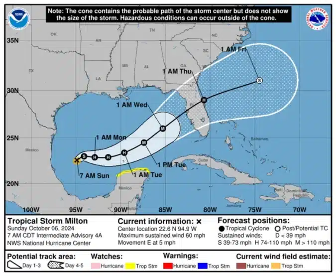
LOCATION…22.6N 94.9W
ABOUT 345 MI…560 KM WNW OF PROGRESO MEXICO
ABOUT 860 MI…1385 KM WSW OF TAMPA FLORIDA
MAXIMUM SUSTAINED WINDS…60 MPH…95 KM/H
PRESENT MOVEMENT…E OR 90 DEGREES AT 5 MPH…7 KM/H
MINIMUM CENTRAL PRESSURE…991 MB…29.26 INCHES
WATCHES AND WARNINGS
——————–
CHANGES WITH THIS ADVISORY:
None.
SUMMARY OF WATCHES AND WARNINGS IN EFFECT:
A Tropical Storm Watch is in effect for…
* Celestun to Cancun
A Tropical Storm Watch means that tropical storm conditions are
possible within the watch area, generally within 48 hours.
Interests in the remainder of the Yucatan peninsula of Mexico, the
Florida Peninsula, the Florida Keys, and the northwestern Bahamas
should monitor the progress of this system.
Hurricane and Storm Surge Watches will likely be required for
portions of Florida late today.
For storm information specific to your area, please monitor
products issued by your national meteorological service.
DISCUSSION AND OUTLOOK
———————-
At 700 AM CDT (1200 UTC), the center of Tropical Storm Milton was
located by NOAA Hurricane Hunter aircraft near latitude 22.6 North,
longitude 94.9 West. Milton has been moving slowly eastward
overnight, and an eastward to east-northeastward motion is forecast
during the next couple of days, followed by a faster northeastward
motion. On the forecast track, Milton is forecast to move across
the Gulf of Mexico and approach the west coast of the Florida
Peninsula by midweek.
Maximum sustained winds have increased to near 60 mph (95 km/h)
with higher gusts. Steady to rapid strengthening is forecast during
the next few days. Milton is forecast to become a hurricane later
today, and it could become a major hurricane while it moves across
the central and eastern Gulf of Mexico.
ACCUWEATHER
As Milton continues to churn over the warm Gulf waters over the next several days, it is expected to strengthen into a major, Category 3 hurricane (on the Saffir-Simpson Hurricane Wind Scale) before making landfall near Tampa Bay, Florida, on Wednesday.
“This is an unusual and extremely concerning forecast track for a hurricane approaching the Tampa Bay area,” warned AccuWeather Chief Meteorologist Jon Porter. “Milton could rapidly intensify into a major hurricane with extreme impacts. This hurricane could create a life-threatening storm surge. Please make sure your family and in friends in this area are prepared.” Read more.
NEWS SERVICE OF FLORIDA
The news service posted an article Saturday based on the 11 a.m. report.
Gulf Coast Could Face Another Hurricane
By Jim Turner, The News Service of Florida. All rights reserved; see terms.
TALLAHASSEE — Less than two weeks after Hurricane Helene ravaged Florida’s Gulf Coast, another major storm is on course to hammer areas still in recovery.
The National Hurricane Center on Saturday said Tropical Storm Milton, which formed in the southwestern Gulf of Mexico, is expected to bring “the risk of life-threatening impacts” to the state’s Gulf Coast in the coming days.
In information posted released at 11 a.m. Saturday, when the storm was still a tropical depression, the hurricane center said the weather system was “forecast to quickly intensify while it moves eastward to northeastward across the Gulf of Mexico and be at or near major hurricane strength when it reaches the west coast of the Florida peninsula mid week.”
“There is an increasing risk of life-threatening storm surge and wind impacts for portions of the west coast of the Florida peninsula beginning late Tuesday or Wednesday,” the hurricane center said. “Residents in these areas should ensure they have their hurricane plan in place, follow any advice given by local officials, and check back for updates to the forecast.”
The hurricane center later issued an update that said the system had strengthened to a tropical storm.
Hurricane and storm-surge watches are likely for parts of Florida on Sunday, according to the hurricane center .
“Another hurricane hitting the Gulf Coast in the wake of #Helene is unthinkable, but we cannot ignore this & must get prepared now,” U.S. Sen. Rick Scott, R-Fla., said Saturday in a post on the social-media platform X.
The meteorological company AccuWeather on Saturday forecast the storm would reach Category 1 or 2 strength on the Saffir-Simpson Hurricane Wind Scale and make landfall Wednesday morning just south of Tampa Bay.
“At this time, the greatest threat to lives and property appears to be due to torrential rainfall that can lead to dangerous, damaging and disruptive urban flooding in Central and South Florida, beginning as early as Sunday and lasting through the middle of next week,” AccuWeather said online. “Besides torrential rainfall and flooding concerns, this storm can bring rough surf, dangerous seas and strong winds that cause power outages and even tornadoes.”
AccuWeather forecast 4 to 8 inches of rain in most parts of Central Florida and South Florida, with heavier rain and totals of 8 to 12 inches in places such as Tampa and Orlando.
Rainfall could include “several inches per hour” in some metro areas, “easily overwhelming the storm drainage system in cities such as Cape Coral, Naples, Port Charlotte, Fort Myers, Tampa, St. Petersburg, Miami, Fort Lauderdale, Orlando and Melbourne,” AccuWeather said.
“Even though much of Florida’s soil is very sandy and can absorb heavy rain quickly, there will still be enough runoff that works into creeks, lakes and rivers to trigger flooding,” AccuWeather said. “Water levels may rise quickly on the smaller streams and lakes but may take a week or two to cycle through rivers such as the Peace, Imperial, Hillsborough, Myakka and St. Johns.”
The storm comes as Florida continues to recover from Hurricane Helene, which made landfall Sept. 26 as a Category 4 storm in Taylor County. It caused extensive flooding in coastal communities as it moved up the Gulf Coast and caused damage across rural North Florida after landfall. It packed 140 mph winds as it made landfall.
At least 15 deaths have been tied to Helene in Florida. More than 200 additional deaths have been reported in Georgia, South Carolina, Tennessee and North Carolina, where rescue efforts have been slowed by rain-inducing mudslides.
If Milton becomes a hurricane and hits Florida, it would be the third landfall in the state this year. Category 1 Hurricane Debby hit Taylor County in August.