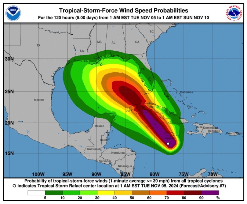
Escambia County Public Safety Director Eric Gilmore expects Raphael to be upgraded to a hurricane later today. The models have it making landfall to the west of us, but where is still undetermined.
BULLETIN
Tropical Storm Rafael Intermediate Advisory Number 7A
NWS National Hurricane Center Miami FL AL182024
700 AM EST Tue Nov 05 2024
…RAFAEL PASSING SOUTHWEST OF JAMAICA…
SUMMARY OF 700 AM EST…1200 UTC…INFORMATION
———————————————-
LOCATION…17.4N 78.4W
ABOUT 80 MI…130 KM SSW OF MONTEGO BAY JAMAICA
ABOUT 230 MI…370 KM SE OF GRAND CAYMAN
MAXIMUM SUSTAINED WINDS…60 MPH…95 KM/H
PRESENT MOVEMENT…NW OR 325 DEGREES AT 13 MPH…20 KM/H
MINIMUM CENTRAL PRESSURE…993 MB…29.33 INCHES
WATCHES AND WARNINGS
——————–
CHANGES WITH THIS ADVISORY:
None.
SUMMARY OF WATCHES AND WARNINGS IN EFFECT:
A Hurricane Warning is in effect for…
* Cayman Islands
* Cuban provinces of Pinar del Rio, Artemisa, La Habana, Mayabeque,
Matanzas, and the Isle of Youth
A Tropical Storm Warning is in effect for…
* Jamaica
* Cuban provinces of Villa Clara, Cienfuegos, Sancti Spiritus,
and Ciego de Avila
A Tropical Storm Watch is in effect for…
* Cuban provinces of Camaguey and Las Tunas
* Lower and Middle Florida Keys from Key West to west of the Channel
5 Bridge
* Dry Tortugas
A Hurricane Warning means that hurricane conditions are expected
somewhere within the warning area. A warning is typically issued 36
hours before the anticipated first occurrence of
tropical-storm-force winds, conditions that make outside
preparations difficult or dangerous. Preparations to protect life
and property should be rushed to completion.
A Tropical Storm Warning means that tropical storm conditions are
expected somewhere within the warning area.
A Tropical Storm Watch means that tropical storm conditions are
possible within the watch area, generally within 48 hours.
Interests elsewhere in Cuba should closely monitor this system.
For storm information specific to your area in the United
States, including possible inland watches and warnings, please
monitor products issued by your local National Weather Service
forecast office. For storm information specific to your area
outside of the United States, please monitor products issued by
your national meteorological service.
DISCUSSION AND OUTLOOK
———————-
At 700 AM EST (1200 UTC), the center of Tropical Storm Rafael was
located near latitude 17.4 North, longitude 78.4 West. Rafael is
moving toward the northwest near 13 mph (20 km/h). A generally
northwestward motion is anticipated over the next few days. On the
forecast track, the storm is expected to move near Jamaica this
morning, be near or over the Cayman Islands tonight, and be near or
over western Cuba on Wednesday.
Maximum sustained winds are near 60 mph (95 km/h) with higher gusts.
Steady to rapid intensification is forecast over the next 24 to 36
hours, and Rafael is forecast to become a hurricane in the
northwestern Caribbean near the Cayman Islands with further
strengthening before it makes landfall in Cuba.
Tropical-storm-force winds extend outward up to 105 miles (165 km)
from the center.
The estimated minimum central pressure is 993 mb (29.33 inches).
HAZARDS AFFECTING LAND
———————-
Key messages for Tropical Storm Rafael can be found in the
Tropical Cyclone Discussion under AWIPS header MIATCDAT3 and WMO
header WTNT43 KNHC and on the web at
hurricanes.gov/text/MIATCDAT3.shtml
WIND: Hurricane conditions are expected in the Cayman Islands by
this afternoon and are also expected in western Cuba and the Isle
of Youth on Wednesday. Tropical storm conditions are expected in
Jamaica through early this afternoon and are expected in parts of
west-central Cuba, possible farther east in central Cuba, and in
the lower and middle Florida Keys on Wednesday.
