
BULLETIN/
Tropical Storm Idalia Advisory Number 8…Corrected
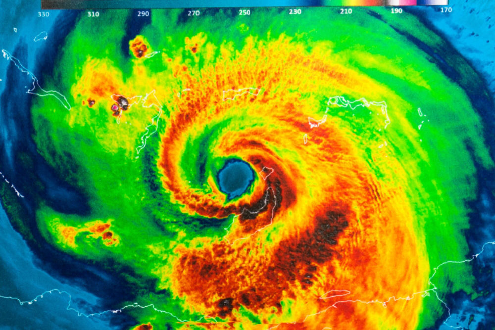
NWS National Hurricane Center Miami FL AL102023
1000 AM CDT Mon Aug 28 2023
Corrected Hurricane Warning end point in the change section of the
watches and warnings
…STORM SURGE AND HURRICANE WARNINGS ISSUED FOR PORTIONS OF THE
WEST COAST OF FLORIDA…
…LIFE-THREATENING STORM SURGE AND DANGEROUS WINDS BECOMING
INCREASINGLY LIKELY FOR PORTIONS OF FLORIDA…
SUMMARY OF 1000 AM CDT…1500 UTC…INFORMATION
———————————————–
LOCATION…20.8N 85.2W
ABOUT 80 MI…125 KM SSW OF THE WESTERN TIP OF CUBA
ABOUT 305 MI…495 KM SSW OF THE DRY TORTUGAS
MAXIMUM SUSTAINED WINDS…65 MPH…100 KM/H
PRESENT MOVEMENT…N OR 360 DEGREES AT 8 MPH…13 KM/H
MINIMUM CENTRAL PRESSURE…990 MB…29.24 INCHES
WATCHES AND WARNINGS
——————–
CHANGES WITH THIS ADVISORY:
A Storm Surge Warning has been issued from Englewood northward to
the Ochlockonee River, including Tampa Bay.
A Hurricane Warning has been issued from the Middle of Longboat Key
northward to the Ochlockonee River, including Tampa Bay.
A Tropical Storm Warning has been issued from Chokoloskee northward
to the Middle of Longboat Key, and from west of the Lockheed
River westward to Indian Pass.
A Storm Surge Watch has been issued from Mouth of the St. Mary’s
River to Altamaha Sound, Georgia.
A Tropical Storm Watch has been issued for the Atlantic coast of
Florida and Georgia from Sebastian Inlet, Florida northward to
Altamaha Sound, Georgia.
SUMMARY OF WATCHES AND WARNINGS IN EFFECT:
A Storm Surge Warning is in effect for…
* Englewood northward to the Ochlockonee River, including Tampa Bay
A Hurricane Warning is in effect for…
* Cuban province of Pinar del Rio
* Middle of Longboat Key northward to the Ochlockonee River,
including Tampa Bay
A Tropical Storm Warning is in effect for…
* Yucatan Peninsula from Tulum to Rio Lagartos, including Cozumel
* Isle of Youth Cuba
* Dry Tortugas Florida
* Chokoloskee northward to the Middle of Longboat Key
* West of the Ochlockonee River westward to Indian Pass
A Storm Surge Watch is in effect for…
* Chokoloskee northward to Englewood, including Charlotte Harbour
* Ochlockonee River to Indian Pass Florida
* Mouth of the St. Mary’s River to Altamaha Sound Georgia
A Hurricane Watch is in effect for…
* Englewood to the Middle of Longboat Key
* West of the Ochlockonee River westward to Indian Pass
A Tropical Storm Warning is in effect for…
* South of the Middle of Longboat Key to Chokoloskee Florida
* West of the Ochlockonee River westward to Indian Pass
A Tropical Storm Watch is in effect for…
* Lower Florida Keys west of the west end of the Seven Mile Bridge
* Sebastian Inlet Florida northward to Altamaha Sound Georgia
HAZARDS AFFECTING LAND
———————-
Key messages for Idalia can be found in the Tropical Cyclone
Discussion under AWIPS header MIATCDAT5 and WMO header WTNT45 KNHC,
and on the web at hurricanes.gov/text/MIATCDAT5.shtml
STORM SURGE: The combination of a dangerous storm surge and the
tide will cause normally dry areas near the coast to be flooded by
rising waters moving inland from the shoreline. The water could
reach the following heights above ground somewhere in the indicated
areas if the peak surge occurs at the time of high tide…
Aucilla River, FL to Chassahowitzka, FL…7-11 ft
Chassahowitzka, FL to Anclote River, FL…6-9 ft
Ochlockonee River, FL to Aucilla River, FL…4-7 ft
Anclote River, FL to Middle of Longboat Key, FL…4-7 ft
Tampa Bay…4-7 ft
Middle of Longboat Key, FL to Englewood, FL…3-5 ft
Englewood, FL to Chokoloskee, FL…2-4 ft
Charlotte Harbor…2-4 ft
Indian Pass, FL to Ochlockonee River, FL…2-4 ft
Mouth of the St. Mary’s River to Altamaha Sound, GA…2-4 ft
Chokoloskee, FL to East Cape Sable, FL…1-3 ft
Flagler/Volusia County Line, FL to Mouth of the St. Mary’s
River…1-3 ft
Florida Keys…1-2 ft
The deepest water will occur along the immediate coast in areas of
onshore winds, where the surge will be accompanied by large and
dangerous waves. Surge-related flooding depends on the relative
timing of the surge and the tidal cycle, and can vary greatly over
short distances. For information specific to your area, please see
products issued by your local National Weather Service forecast
office.
WIND: Hurricane conditions are expected within the hurricane
warning area in western Cuba later today. Winds are expected to
first reach tropical storm strength by this morning, making
outside preparations difficult or dangerous. Preparations to
protect life and property should be rushed to completion.
Hurricane conditions are expected within the hurricane warning area
in Florida by late Tuesday or Wednesday, with tropical storm
conditions beginning on Tuesday.
Tropical storm conditions are expected in the Dry Tortugas
beginning late today and within the tropical storm warning area
along the Florida Gulf coast on Tuesday.
RAINFALL: Idalia is expected to produce the following rainfall
amounts:
Portions of the west coast of Florida, the Florida Panhandle,
southeast Georgia and the eastern Carolinas: 4 to 8 inches from
Tuesday into Thursday. Isolated higher totals of 12 inches possible,
primarily near landfall in northern Florida.
Areas of flash and urban flooding, some of which may be locally
significant, are expected across portions of the west coast of
Florida, the Florida Panhandle, and southern Georgia Tuesday into
Wednesday, spreading into portions of the eastern Carolinas
Wednesday into Thursday.
SURF: Swells generated by Idalia are affecting portions of the
southern coast of Cuba and eastern Yucatan. These swells are
likely to cause life-threatening surf and rip current conditions.
Please consult products from your local weather office.
TORNADO: A few tornadoes will be possible starting Tuesday along the
west central Florida coast and the tornado threat will spread
northward into the Florida Big Bend area by Tuesday night.
NEXT ADVISORY
————-
Next intermediate advisory at 100 PM CDT.
Next complete advisory at 400 PM CDT.